Paul Lane Bungalows, Mousehole
The Brief
RIDA Reports was appointed by the site owner to undertake a detailed flood risk assessment for a proposed development located on land adjacent to 6 Paul Lane Bungalows in Mousehole. The project involves the construction of a new residential dwelling on the site. Classified as a ‘More vulnerable’ development, the project required a comprehensive assessment to evaluate its viability and ensure it would be safe from current and future flooding.
Why the Client Chose RIDA
Given the complexities of proposing a new residential dwelling in an area with known environmental constraints, the client required specialist flood risk expertise. RIDA was selected to provide the technical evidence and robust mitigation strategies necessary to navigate stringent national and local planning policies, ultimately supporting the viability of the planning application.
The Challenge
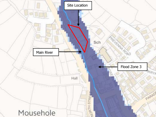
The primary constraint for this site was its location within Environment Agency Flood Zone 3, indicating a high probability of fluvial flooding (a 1% or greater annual probability). Because the proposed new dwelling is classified as a ‘More vulnerable’ land use, the development was subject to strict National Planning Policy Framework (NPPF) requirements, specifically the need to pass both the Sequential and Exception Tests. Furthermore, the local area has a well-documented history of complex flooding incidents, including surface water runoff, overloaded culverts, and insufficient channel capacities in the nearby Paul Stream and Tumble Tyn Stream.
The RIDA Difference
To address these challenges, RIDA conducted a detailed flood risk assessment in strict accordance with the NPPF and the Cornwall Council Preliminary Flood Risk Assessment. The fluvial flood risk was evaluated using Environment Agency data to satisfy the sequential risk-based approach. To ensure the development could safely manage the identified risks, RIDA outlined specific mitigation strategies. These included positioning critical services—such as electrical wiring, communications, and gas and water meters—above predicted flood levels, sealing all service entries with expanding foam, and utilising closed-cell insulation for any pipes located below the flood level. Additionally, site-specific drainage enhancements were proposed, such as replacing a historic barrier on the adjacent Leat / Paul Stream with a marine-grade grid to improve flow and manage exceedance.
The Outcome
The detailed flood risk assessment successfully established the framework required to meet the stringent conditions of the Exception Test. By detailing practical flood resilience measures and watercourse improvements, the report demonstrated how the new dwelling could be made safe for its 50 to 100-year design life without increasing flood risk elsewhere. The comprehensive strategy provided the robust technical evidence necessary to support the client’s planning application.