- Fastest in the UK: Flood Risk Assessments in 48 Hours • Drainage Strategies in 5 Days.
Flood Risk Assessment UK

What Is a Flood Risk Assessment?
A flood risk assessment (FRA) is a technical report that evaluates flood risk within the context of national flood risk assessment policy and datasets, including the national flood risk assessment and Environment Agency mapping. It considers how flooding could affect a specific site, taking into account:
• River and tidal flooding
• Surface water flooding
• Groundwater flooding
• Flood zones and floodplains
• Climate change impacts
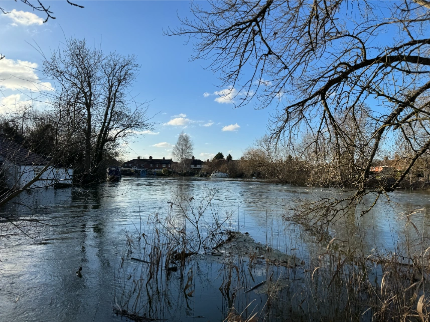
The purpose of a flood risk assessment is not only to identify flood risk, but to explain whether that risk is acceptable, how it may affect development or property use and what mitigation measures may be required. While national datasets provide a strategic overview of flooding Great Britain, a site-specific assessment is essential to properly understand local conditions.
Flood Risk Assessment Cost
The cost of a Flood Risk Assessment depends on several site-specific factors. These include flood zone classification, surface water risk, site size, development type, and whether additional analysis is required. The examples below show typical starting costs for common project types in our company.
House extensions & change of use
From £650.00
1–2 new dwellings (small residential development)
Used for small residential developments involving one or two new dwellings.
Larger residential & commercial developments
Price on application
Required for larger residential or industrial developments where flood risk assessment must address site-wide impacts, mitigation measures, and safe access.
Flood Warning and Evacuation Plans
Price on application
Priority Flood Risk Assessment delivered within 48 hours, regardless of flood zone or project size
(subject to data availability).
Learn more about Flood Risk Assessment cost and what factors influence pricing across different development types.
Not sure which category your project falls into? Contact us for further details.
Our Clients


With a strong background in flood risk assessment, our team delivers data-led analysis for land and property, supporting residential, commercial and infrastructure projects at all scales.
When Is a Flood Risk Assessment Required?
A Flood Risk Assessment is required in specific situations where flood risk may affect planning decisions, development proposals, or property use.
Flood Zone location
A Flood Risk Assessment is required when a site is located within Flood Zone 2 or Flood Zone 3, where there is a higher probability of river or tidal flooding.
Surface water flood risk
Even outside river flood zones, an assessment may be required where surface water flood risk is identified on Environment Agency mapping, as this can significantly affect site safety and design.
Planning applications
A Flood Risk Assessment is required in specific situations where planning policy identifies the need for a Flood Risk Assessment, or where flood risk may affect development, property use, or transaction decisions.”
Property and due diligence
Flood Risk Assessments are also used for property transactions, insurance inquiries and legal due diligence where understanding flood exposure is essential, with a Flood Risk Report providing a clear summary of relevant flood risk information
Flood Risk Assessment for Planning Applications
For planning permission, a Flood Risk Assessment for planning must demonstrate compliance with national and local planning policy and clearly address site-specific flood risk.
Common scenarios include:
- A site is located in Flood Zone 2 or Flood Zone 3
- Surface water flood risk is identified on Environment Agency mapping
- A planning application is being submitted
- A local authority specifically requests flood risk information
- Flood risk needs to be understood for property purchase or sale
How Flood Risk Assessments are prepared?
GIS and specialised software are used to analyse flood risk in detail, with findings reviewed against Strategic Flood Risk Assessments (SFRA) where relevant.
What Does a Flood Risk Assessment Include?
The scope of a Flood Risk Assessment varies depending on the location and nature of the development, with the aim of identifying flood risk sources, potential impacts, and whether those risks can be safely managed. The assessment considers how the site relates to wider flood risk zones, as well as national and local flood risk frameworks, including the national flood risk assessment.
The flood risk assessment methodology includes
- Location plans identifying the site and its surrounding context
- Assessment of site characteristics, including levels and topography
- Evaluation of flood risk from rivers, the sea, surface water, groundwater and reservoirs
- Use of national and local flood risk datasets and mapping
- Consideration of flood risk with climate change over the lifetime of the development
- Review of relevant design drawings to inform mitigation and layout
- Final report containing all findings and associated appendices
Maps
How Flood Risk Is Assessed Using Maps and Data
Flood Risk Assessments typically draw on official data, including Environment Agency Flood Risk Map data, surface water flood mapping, long-term flood risk data, groundwater flood susceptibility, and local authority records. These datasets help identify whether a site lies within recognised UK flood areas, but they must be interpreted alongside local topography and site constraints.
Online Flood Risk Map information is a useful starting point, but it does not replace a professional Flood Risk Assessment, particularly for planning or development purposes. Understanding the flood zone a site falls within is a key first step in assessing flood risk.
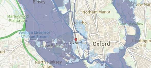
You can also check the following maps
- Flood Maps England: Environment Agency Flood Map for Planning
- Scotland: Scottish Environment Protection Agency flood maps
- Wales: National Resources Wales flood map
- Northern Ireland: Flood maps (NI)
Flood Risk Assessments for House Extensions
We have delivered a helpful checklist guide if you are planning an extension on your property.
What Does a Flood Risk Assessment for an Extension Cover?
Flood Risk Assessments for house extensions are proportionate to the scale of development but typically include:
• Review of Environment Agency flood maps and available datasets
• Assessment of fluvial, surface water, groundwater, tidal, and sewer flooding
• Confirmation of flood zone classification and planning implications
• Consideration of finished floor levels and site layout
• Identification of appropriate mitigation measures, where required
• Clear conclusions suitable for planning determination
Our Level of Support
Site Visit
On-site inspection carried out by a flood risk specialist to assess site-specific conditions Recommended for higher-risk or complex sites
Fast Track
Priority Flood Risk Assessment delivery for time-sensitive planning applications, without compromising compliance or technical quality.
Report only
Planning-compliant Flood risk report to support application registration or validation on low-risk sites.
Planning a house extension or development?
Get the right level of flood risk support from the start.
Who Prepares Flood Risk Assessments?
Flood Risk Assessments must be prepared by suitably qualified professionals with expertise in flood risk, planning policy, and regulatory requirements. Local planning authorities typically expect assessments to be completed by a competent flood risk consultant who can clearly assess site-specific flood risk and support planning decisions with robust, evidence-based conclusions.
Learn more about our flood risk consultants and how our experience supports successful planning outcomes.
The flood risk assessment methodology includes
- Flood risk consultants and flood risk assessors
- Civil, drainage, or environmental engineers
- Flood risk engineers and hydrology specialists
- Professionals experienced in flood modelling and data analysis
- Consultants familiar with Environment Agency mapping and planning policy
Why choose RIDA for your Flood Risk Assessment?
Specialist flood risk and drainage consultants
We focus exclusively on flood risk and drainage, delivering technically robust assessments aligned with planning policy and regulatory guidance.
Experience with planning authorities across the UK
Our reports are prepared with a clear understanding of local authority and Environment Agency expectations across England.
Clear, proportionate, and defensible reporting
Assessments are tailored to the level of flood risk and scale of development, providing evidence-based conclusions that support planning decisions.
Straightforward advice, without unnecessary complexity
We provide practical, easy-to-understand advice that helps clients move forward confidently through the planning process.
Our Related Flood Risk Services
These services support and complement the Flood Risk Assessment process, providing the technical analysis, modelling, and planning tools required to fully understand and manage flood risk.
Detailed sequential and Exception Tests
1D & 2D Detailed River Modelling
Our detailed flood river models are cost-effective, giving your development the best chance to achieve planning approval.
Flood Warning and Evacuation Plans
What Our Customer Says
We have had the pleasure of working with Arge at RIDA over several years and throughout this time the experience has consistently been very good. What stands out most is their responsiveness - any queries or issues have always been addressed promptly, which has given us great confidence and peace of mind.
Frequently Asked Questions
Whether or not a Flood Risk Assessment (FRA) needs to be conducted is dependent upon the location of a given project. Typically this will apply to projects which will take place in Flood Zones 2 or 3, or where there is potential for flooding over an area of 1 Hectare or more. However, due to the mapping of flood risk, areas that do not currently fall within Flood Zones will still require a FRA to determine the flood risk to your property and site. For more guidance, check out the government website: https://www.gov.uk/guidance/flood-risk-assessment-for-planning-applications
The cost of a Flood Risk Assessment depends on the site location, flood risk level, and project type. Our Flood Risk Assessments typically start from £750, with a fixed price confirmed once the site details have been reviewed.
The Environment Agency states that for simple, low-risk developments, such as small house extensions, a flood risk assessment may be prepared by the applicant. In practice, though, most people prefer to hire professionals who can guide them through the process so they can ensure their project continues to move forward without delays.
Flood Risk Assessments are completed by engineers or consultants who specialize in flood risk analysis. Our team of chartered engineers possess both technical expertise and experience working under current law, as well as the ability to understand local planning and flood risk assessment regulations.
Depending on the extent of your flood risk zone and the size of your project, the time it takes to complete a flood risk assessment will vary significantly. Once submitted the Flood Risk Assessment to the Environment Agency, you should receive a response from them within 21 working days.
If your site meets the criteria (e.g., in Flood Zone 2/3 or >1 hectare), the Local Planning Authority (LPA) will likely refuse to validate or approve your application until a satisfactory FRA is submitted.
Climate change allowances are predefined adjustments applied within flood risk modelling to represent the anticipated effects of climate change over a specified future period, such as increases in rainfall intensity, river flows, or sea levels. These allowances are used to test how flood risk may evolve under future climate scenarios and form part of the modelling assumptions, rather than constituting flood risk outputs themselves.
Generally, an FRA is considered valid for the duration of the planning application. However, if more than five years have passed, you must provide evidence that the flood data and climate change projections haven't changed.