England can flood from four different sources, and each source has its own flood zones. The environmental agency has published a map for planning that divides areas into three flood risk zones based on rivers and the sea.
The other two flood sources, flood from surface water and groundwater, also have their maps. The “Risk of flooding from surface water” has been published by the EA, and Groundwater flooding by the British Geological Survey (BGS)
These zones and their corresponding maps identify flood probability, help in planning permission and prevent flood damage. These zones are important for houseowners, developers and consultants when deciding on property development and flood risk assessment. We will cover all these sources and zones of flood risk in this guide.
What Are Flood Risk Zones Based on Rivers and the Sea?
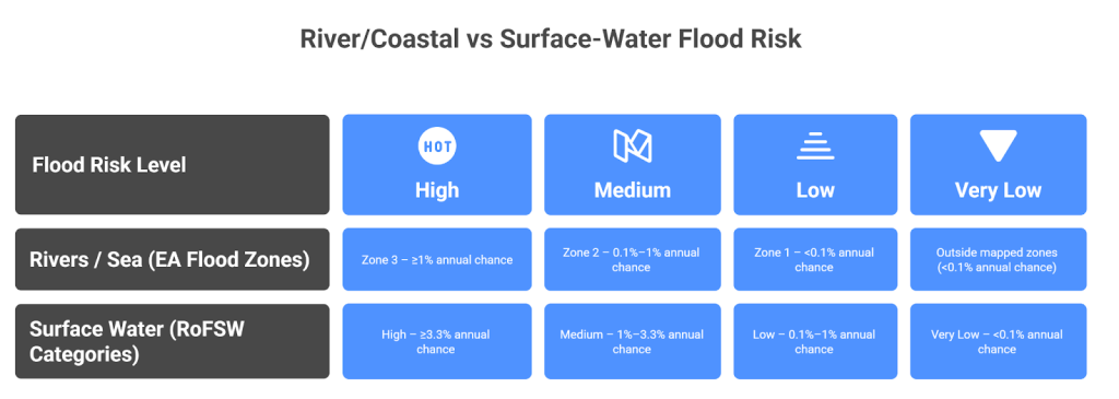
Flood Zones are the official categorisation of England based on flood probability from rivers and the sea. There are three zones: flood zone 1, flood zone 2 and flood zone 3. Flood zone 3 has the highest risk of flooding, and flood zone 1 has the lowest.
These zones are used for guidance for developers and planners to evaluate sites, understand flood risks and perform flood risk assessment. Please note, these zones do not guarantee flood nor do they show flood depth.
During flood risk assessment at Rida reports, our chartered engineers will provide data on the depth of water. We hold more than 750 river models in the UK. Get in contact with us for more details.
Flood Zone 1
This zone is situated away from rivers and the sea, so it faces less chance of flooding annually. As less has <0.1% meaning less than 1-in-1,000 each year. All sorts of developments are generally safe and allowed, including housing without an FRA. An FRA is only required when the land area in zone 1 is bigger than 1 hectare or drainage issues exist.
Flood Zone 2
Flood zone 2 exists between zone 1 and zone 3, so it carries a medium risk of flooding. According to the environmental agency, this zone carries an annual chance of flooding between 0.1%- 1% from rivers, or 0.1%–0.5% from the sea. Developments are allowed in this zone, but only after flood risk assessment. Some of the sites in zone 2 may require raised flood floors based on an FRA report. For example, policy guidelines ask developers to build raised flood floors of at least 600 mm for every new residential site in zone 2
Flood Zone 3
Flood Zone 3 is situated closest to rivers and the sea, hence carrying the highest risk of flooding. This zone carries an annual flood probability of ≥1% annual flood chance from rivers, or ≥0.5% from the sea. Almost always, less-risk flood zones are looked for before choosing zone 3 for development. And if the development could only be done in zone 3, then it has to pass the flood risk assessment.
This zone also has restrictions on the type of development; for example, housing is prohibited unless it passes the exception test. Zone 3 is further divided into two categories:
Zone 3a (≥1% river flood or ≥0.5% coastal flood per year), the highest probability Zone.
Zone 3b acts as a functional plain, where flood water is required to reach, for example, a storage facility.
For a full breakdown of what these classifications mean for your planning application, see our guide to Flood Zone 3 requirements.
Characteristics of Flood Map for Planning
The flood map for planning tells about the flood risk of all the areas of England. It is available on the government’s website and can be printed as well. This map uses colours to separate each zone and make identification easy. For instance, zone 3 is the dark blue zone of the map, the flood zone is light blue and zone 1 is clear.
This map has an interactive interface, meaning you can add a specific address to see where it is located. It notifies you on the map if you searched area comes within 20 meters of a river, an important point when planning permission.
One limitation of this map is, it is static and does not provide real-time updates. It is used for long-term flood probability, so for day-to-day updates, use 5-day weather reports and news channels.
By now, we know flood has four sources, and we have covered rivers and the sea in detail. The next two flooding sources are Surface water and groundwater. Fortunately, we have a map for each.
Surface flooding occurs due to heavy rainfall and water outflow from drains and sewers. The Environment Agency calls it “ surface water flooding “, and RoFSW (Risk of Flooding from Surface Water) has mapped the flood zones of surface water.
This map divides zones into four categories, called high risk, medium risk, low risk and very low risk zones. High risk zone has >3.3% chances of flooding, medium zone has 1-3.3% chances of flooding, low risk zone has 0.1-1% chances of flooding, and very low risk zone has a chance of only 0.1%
On the other hand, in groundwater flooding due to an extended period of rain, groundwater seeps out and causes flooding, for example, in basements. British Geological Survey (BGS) uses the geology of an area and past groundwater records to indicate how likely an area is to flood from groundwater. The data set provided by BGS divides England into three classes: A, B, and C.
Class A has the lowest risk of groundwater flooding.
Class B has a medium chance of flooding, and if a flood occurs, then places like basements can flood, and it won’t reach too high.
Class C has the highest risk of flooding, and in case of flooding, it can change into a surface water flood. Classes B and C mostly require a flooding risk assessment for planning permission.
Foundation Solutions and Mitigation Strategies For High-Risk Flood Zones
In high-risk flood zones, foundation design and building construction have to be done carefully. For example, as a form of zone 3 foundation solution, it is recommended to go for an elevated construction strategy. The finished floors in zone 2 should be raised at least 2 feet above the surface, and in zone 3, they should be raised at least 3 feet.
All construction in high-risk flood zones should be done using flood-resistant materials. Concrete, block words and specially designed flood-resistant boards are some of the examples of flood-resistant material. It is also advised to install electric sockets higher on walls, and walls should be sealed.
Install no-return valves in drains to prevent groundwater flooding and reverse flow of water.
Generally, it is not advised to construct basements in high flood risk zones. It increases the chances of flooding and a weak foundation. And planning authorities usually do not accept applications for basements in high flood risk zones.
Insurance and Finance in Flood Risk Zones
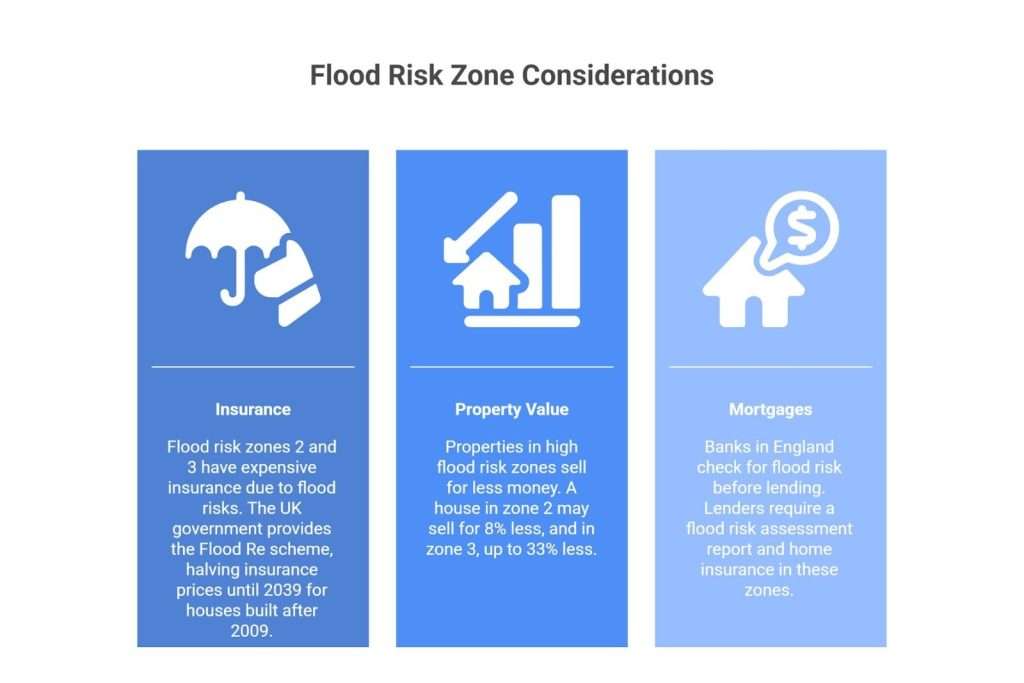
Flood risk zones 2 and 3 have expensive insurance because of the obvious flood risks and their damage. But fortunately, the UK government provides the Flood Re scheme (runs until 2039), which halves the insurance price of these zones. But the flood re scheme is only applicable to houses built after 2009.
Properties in high flood risk zones sell for less money. On average, a house in a flood risk zone 2 may sell for 8% less.Even some properties in the highest risk zone 3 may sell up to 33% less.
Banks in England now check for flood risk before agreeing to lend. Lenders that provide mortgages in these zones require a flood risk assessment report and home insurance.
In short, take extra time and effort in analysing every aspect of flood risk zones 2 and 3, so you are prepared for the future with the best precautions.
Other mapping systems all also used outside England and managed by different authorities. Scotland has Scotland flood map published by SEPA, which provides flood risk probability by rivers and the sea. In Wales, Natural Resources Wales and the NI River agency also publish similar maps.
All these mapping systems use almost the same flood risk definitions, so you will find similarities among them.
Flood Zone 3 has the highest risk of flooding since it is the closest to either the river or the sea. This zone carries a probability of ≥1% for river flooding (or ≥0.5% for sea flooding) and is subdivided into Flood Zone 3a (high probability) and Flood Zone 3b (functional floodplain), with 3b representing the greatest constraint on development.
Zone 1 is the lowest risk zone with a 0.1% annual chance of flooding. All kinds of developments are allowed in this zone. And unless an area is bigger than 1 ha, no Flood risk assessment is needed for planning permissions.
The flood maps show different flood zones depending on the flood risk they carry. There are three types of flood zones, zones 1,2 and 3 available on the map with different colours. With 1 at the lowest risk and unshaded, while 3 is at the highest risk with a dark blue shade.
You will find the most accurate and fastest information about flood risk using EA’s official tool. Go to the Environment Agency’s flood map for planning or the government’s long-term flood risk checker, add your address or postal code, and get your information. You can also print the flood map for planning.
Flood mapping is a process of converting hydrological and climate data into spatial maps to represent the likelihood of flooding in an area. The flood mapping translates flood risk probabilities into a visual format.
Get Your Expert Flood Risk Assessment Today
Understanding flood risk zones of England is important for anyone buying, building, or developing land in England. You must also consider surface water and groundwater risks, which have their own maps and categories. A site with low river flood risk can still be vulnerable to pluvial floods or a high water table. But if you not only want detailed analysis, mitigation strategies, and planning permission assistance, you might need professionals for 100% success.
Contact a professional UK-focused Flood Risk Assessment (FRA) today to guide the planning process and design of flood-safe measures. RIDA Reports specialises in flood risk consultancy for England. We interpret the flood map, perform sequential/exception tests, and implement mitigation strategies customised to your site. Contact RIDA Reports today for expert guidance on your specific flood risk zone and ensure your project is compliant, safe, and sustainable.