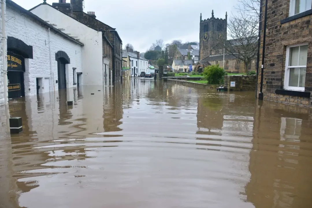
According to the Environment Agency, flooding can come from rivers, the sea, surface water, or groundwater. Each source carries its own risks and risk zones. While it is important to know about flood sources and flood maps, it is equally important to know about real-time forecasts and flood warnings to act on time. For example, Storm Babet in October 2023 -Released dozens of flood alerts in hours, and protected nearly 100,000 properties in the UK.
This blog focuses on live flood alerts, weather forecasts, preparations, and flood mapping tools to protect your home and family from flood risks. We cover UK-wide (England/Wales/Scotland/NI) systems, flood zones, insurance, and safety steps to make sure you’re ready before, during, and after heavy rain.
UK’s Official Flood Warning System
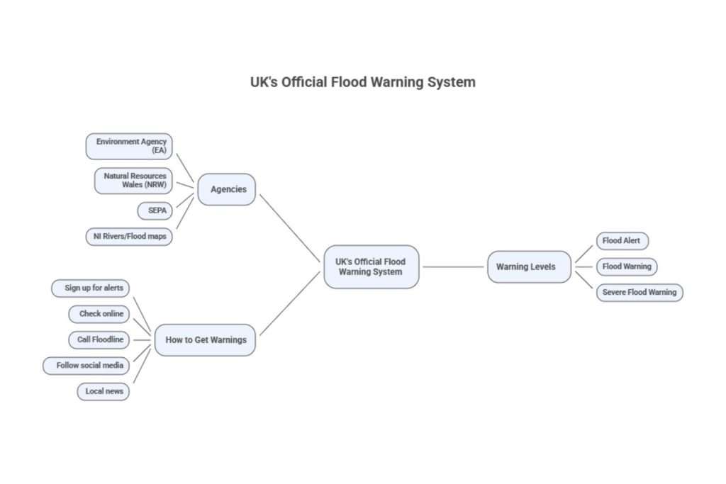
Each UK nation has its own agencies for flood alerts and flood prevention tools:
- In England, the Environment Agency (EA)
- In Wales, Natural Resources Wales (NRW)
- In Scotland, SEPA
- In Northern Ireland, the NI Rivers/Flood maps
We will focus on England’s system, which is similar to Wales’/Scotland’s.
Warning Levels: Scotland’s NRW uses three main levels:
- Flood Alert: “Flooding is possible, Be prepared” means be prepared and keep an eye on the real-time updates.
- Flood Warning: “Flooding is expected. Immediate action required.” This warning is for people to take action immediately. For example: store food, move valuable items upstairs, and avoid flood water.:
- Severe Flood Warning: “severe flooding. Danger to life.” This means the flood is causing an imminent disaster. Evacuate if in a flood zone, and keep your emergency kit with you at all times.
Flood Alerts are issued 2–12 hours before flooding. Flood Warnings are released 30 minutes to 2 hours before expected flooding. Severe Warnings are issued at any time if life is at risk.
In England, EA issues these alerts/warnings for rivers, the coast, and some groundwater. They do not release these warnings for surface water( flash flood from heavy rainfall). Instead, weather alerts and the local council communicate surface water flood alerts. Residents also mostly rely on the Met Office for rain warnings and flash floods.
How to get Flood warnings
- Sign up for alerts: In England, sign up for free EA warnings on GOV.UK(text/email/phone).
- Check online: Go to the Check for Flooding online tool (GOV.UK) to see current alerts by postcode. It also shows the next 5-day forecast.
- Call Floodline: Floodline (0345 988 1188) offers recorded updates 24/7.
- Follow social media: EA (@EnvAgency on X) and local agencies update on Twitter/X.
- Local news: TV/radio cover regional flood bulletins during major events.
How to Identify High-Risk Flood Areas Through Maps
Maps are an authentic way to identify flood risk areas and flood sources. For example, the flood map for planning by EA provides flood prediction for long-term flood risks and divides areas into three flood zones based on the severity of flood. A flood map for planning is an excellent tool to identify the flood risk of your area, and even get general information about where your area resides.
Flood Map for Planning (England): It shows zones:
- Zone 3a/3b (High Risk) – >1% annual river/coastal flood chance (1-in-100 or worse)
- Zone 2 (Medium) – 0.1–1% chance (1-in-1,000 to 1-in-100).
- Zone 1 (Low) – <0.1% (less than 1-in-1,000).
.
For flood risk from surface water, residents can use the RoFSW map. It was last updated in January 2025, and this map predicts where heavy rain will pond. It covers the surface water risk, not covered by the flood map for planning. The map also categorises areas into High/Medium/Low risk by depth and annual chance:
- High = >3.3% chance each year of any inundation
- Medium = 1–3.3%; Low = 0.1–1%).
You may use this map and flood map for planning to identify all flood areas of different sources ( rivers, the sea, a nd surface water)
How Different Flood Areas Behave During a Flood
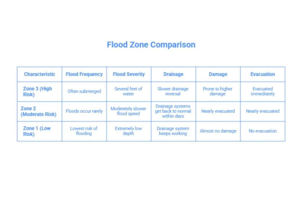
Flood zones indicate frequency and severity, which affect preparation:
- Zone 3 (High Risk): These areas often get submerged with several feet of water in major flood events. Areas in flood zone 3 also experience fast flooding and slower drainage reversal to normal. In short, this zone is prone to more serious damage during a flood. People in this zone are evacuated immediately during a flood.
- Zone 2 (Moderate Risk): Because floods occur rarely in flood zone 2, this zone stays protected most of the time. But the chances of flooding are never zero. During a flood, the speed of the flood is moderately slower than zone 3. The drainage systems get back to normal within days, and people are rarely evacuated.
- Zone 1 (Low Risk): Zone 1 has the lowest risk of flooding. In case of flooding, the depth is extremely low, the drainage system keeps working, and almost no damage to properties occurs, especially when you have used mitigation strategies.
It is best to get a flood risk assessment of your area to identify the flood risk your house carries, not just your area. The flood risk assessment by Rida reports identities and protects your property through professionally tested and proven strategies. Especially if you’re developing in flood zones 2 or 3, you need a flood risk assessment for permission planning. We will not only assess your area, but also recommend risk mitigation strategies and generate a technical FRA to make your development in England easier and safer!