NAFRA2 Explained: The New Environment Agency National Flood Risk Assessment
Flood risk is increasing in England. As a matter of fact, the previous number for properties at risk of flooding (6.3 M) could reach up to 8 million properties by 2030. Climate change is playing a key role in this emergence, and because of this, the Environment Agency has developed a new national flood risk assessment model ( NAFRA2).
In this guide we explain what NAFRA2 is, how it differs from NAFRA 2000 and how it affects development in England where a flood risk assessment is often part of the planning process.
What is the National Flood Risk Assessment 2 (NAFRA2)?
NAFRA2 is a new national model for flood risk assessment in England by the Environment Agency. This new model has replaced the previous NaFRA assessment, which was published in mid-2000 and later updated in 2018.
According to the Environment Agency, NAFRA2 combines information on flood risk from rivers, the sea and surface water. It provides a complete picture of present and future flood risk in England from rivers, the sea and surface water.
NAFRA2 is a country-wide flood model based on hundreds of existing hydraulic flood models. It is high resolution and has a richer dataset. Another advancement in NAFRA2 is that it provides flood depth information along with flood zones. NAFRA2 works like a GPS rather than an old paper flood map.
Why was NAFRA2 Published?
As we stated earlier, the last update for the England Flood Risk Assessment was in 2018, and the original baseline data inside it was almost 20 years old. This obviously shows a need for updated data. So the outdated data raised a need for update, and the Environment Agency acted on it.
The second factor was the advancement of technology. The Environment Agency now has advanced technology to understand England’s flood risk and perform multiple flood models. Even the EA itself notes that the change in at-risk properties from 5.2 M to 6.3 M properties does not reflect a real-world increase in flood risk but rather a better understanding of risk due to improved data and advanced technology.
The third factor was the motivation to integrate all sources of flood risk into one place. Previously, the official flood map for planning did not account for surface water, and NAFRA 2 has fixed that. The new flood risk assessment accounts for rivers, sea and surface water.
Finally, climate change has been affecting flood risk, and it has to be better factored in. The NAFRA2 explicitly uses UK climate projections (UKCP18) in the new model. In fact, NAFRA2 is the first national flood map to include these climate allowances. Climate change integration allows planners to plan development more efficiently and understand an area’s flood risk better.
How to Access NAFRA2
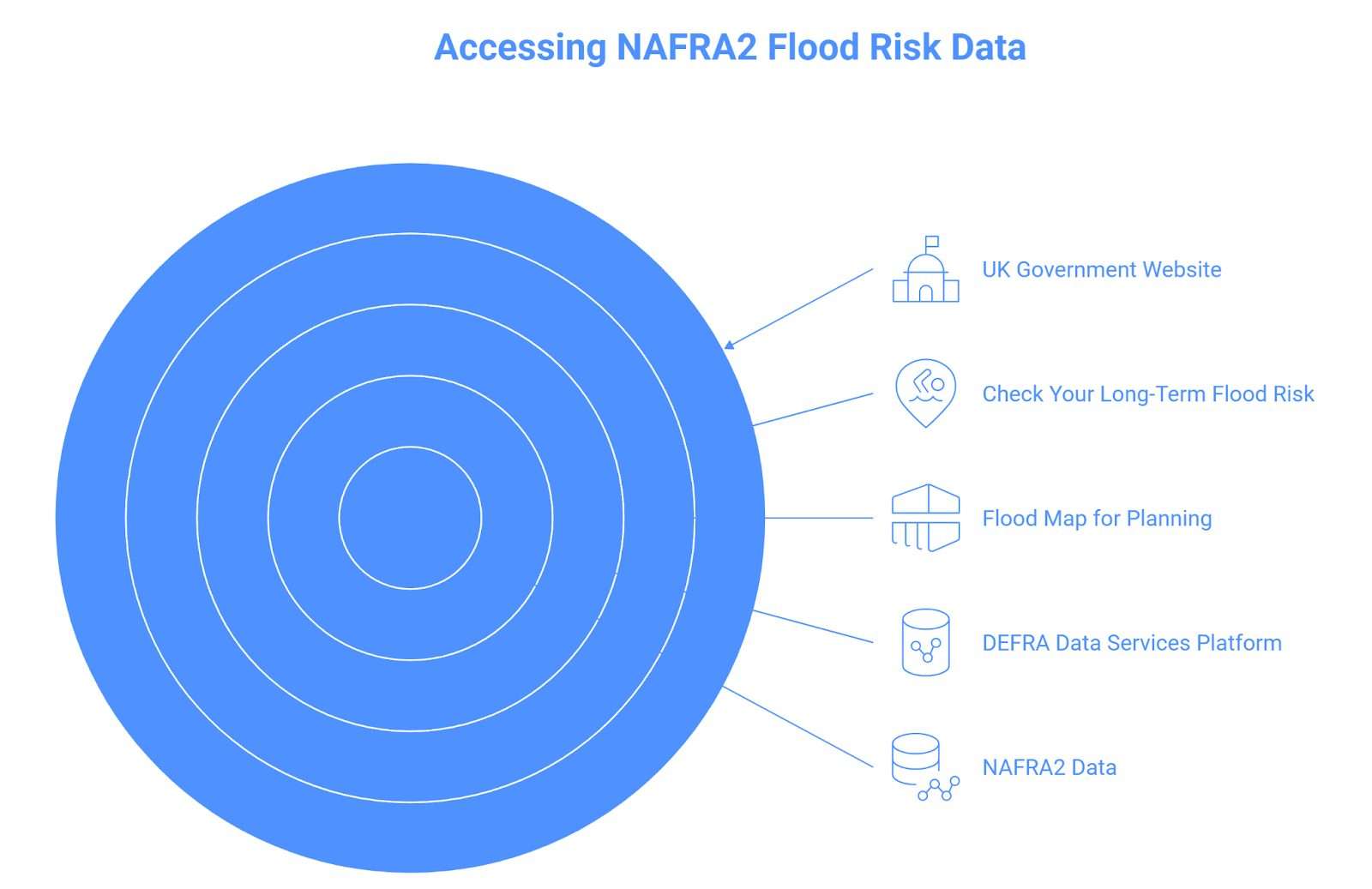
The UK government’s website and several online flood risk service tools allow users to access NAFRA2.
Check Your Long-Term Flood Risk
NAFRA2 data is available on the “check your long-term flood risk” online service available on the gov.uk website. This interactive map allows users to enter their postcode or address and check the current and future flood probability in England. For instance, from Jan 2025, users are now able to see if they are in flood risk zone 2 or flood risk zone 3. This online tool is a straightforward way for homeowners to check their flood risk from the comfort of their home.
Flood Map for Planning
The second way to access NAFRA2 data is through the flood map for planning, which is an online map published by the Environment Agency for formal planning. This map divides the area of England into three flood zones based on flood probability. The map now provides flood zone information with climate change allowances and accounts for pluvial flood extents alongside rivers and the sea.
DEFRA Data Services Platform
All NAFRA2 datasets, including flood probabilities and depth, are available on DEFRA Data Services. The DEFRA Data service is especially helpful for engineers and GIS specialists who can download the raw layers to use in local analysis and incorporate them into bespoke mapping tools.
What are the Differences Between NAFRA2 and the Previous EA Flood Maps
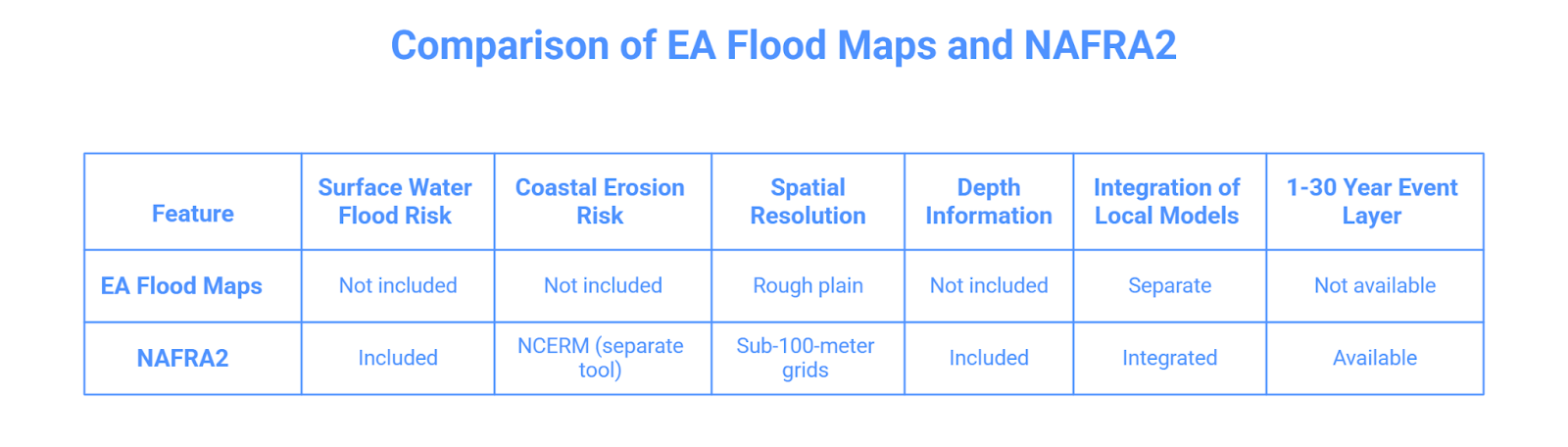
The previous EA flood maps did not include surface water flood risk. Now NAFRA2 has included surface water flooding, alongside rivers and sea flooding. This means now areas which are historically outside the floodplain but still prone to flash flooding will show in flood risk zone 2 or 3. This new change has made things easier for planners as well, who previously had to guess or perform separate surveys to check for surface water flood risk.
There was another map released alongside NAFRA2, known as the National Coastal Erosion Risk Map (NCERM). The NCERM predicts where coasts may erode under different climate change scenarios, whereas NAFRA2 predicts flood risk based on sea level rise allowances. These two are separate tools, but can be used together by planners and developers to understand all sorts of flood risk based on every possible flood source.
The new NAFRA2 maps are spatially high resolution; in effect, this means they provide sub-100-meter resolution grids instead of a simple rough plain. The NAFRA2 also provides depth information and more location-specific information. For instance, it tells whether a specific part of a site is at risk or the entire area.
NAFRA2 has integrated all local flood models with national flood data. Developers and planners no longer have to put together different local flood models and national flood maps. Now all flood risk information from rivers, the sea and surface water is in one place.
NAFRA2 has also introduced a new 1-30 year event layer for both river and sea flooding. This was never available previously at the national level. In short, NAFRA2 is more advanced and not only helps with flood prediction but will make things easier for developers and planners.
Practical Effects on the Planning and Design Process
NAFRA2 will have several practical effects on the planning and design process:
Strategic Flood Risk Assessments (SFRA)
Flood risk assessment is a key part of development in England, especially in flood zones 2 and 3. Developers and planners require flood data, climate change and different flood models to perform an efficient SFRA. NAFRA2 will provide all this crucial data in one place, which will not only help in flood risk assessment but will be a government-proven source of data.
Suitability and Compliance
According to the National Planning Policy Framework (NPPF), a sequential test is performed to check for a less risk side or prove that there is no less risk flood site available to continue development in a high-risk zone. The updated NAFRA2 maps account for climate change and surface water, which may put some areas previously in low-risk zones into high-risk zones. So it is extremely important for developers and planners to check updated EA flood maps so they stay compliant with national policies.
Consistent National Data
NAFRA2 is now a source of national and consistent data in one place. This will result in more consistent data collection and flood model scenarios. Helping developers skip the hard work of knitting together local flood models and old EA flood maps.
What NAFRA2 Means for UK Homeowners
NAFRA2 affects ordinary homeowners, in terms of insurance, how they should design their properties, and provides more clarity on flood zone 2
Updated flood risk data will impact insurance and insurance premiums. If NAFRA2 puts an area previously in a low flood risk zone into a high flood risk zone, it may automatically face expensive premiums. As one study notes, a 1% increase in flood risk reduces the value of property by 0.13–0.19%.
The new NAFRA2 flood maps will impact how homeowners design their properties. The new maps now predict climate change and surface water in addition to rivers and the sea. The homeowners might have to take extra measures and improve their mitigation strategies based on what information NAFRA2 provides about their area.
Homeowners often seem confused about flood zone 2 and how it is different from flood zone 3. The Environmental Agency has clarified this, and it states that flood zone 2 means it carries a risk of 0.5-0.1% annual flood from coastal areas and 1-0.1% annual chance from rivers.
In summary, homeowners can get detailed information about the flood of their area online, they can plan well on what area to choose for development, and they can also design flood-safe properties and stay up to date on long-term flood risk.
NAFRA2 is the updated flood model by the Environment Agency, replacing the previous NAFRA model updated in 2018. NAFRA2 includes flood risk from rivers, the sea, and surface water. It also predicts flood depth and the influence of climate change.
The NAFRA2 is available on the Environment Agency’s website. You can find its data on the "Check your long-term flood risk" on the gov.uk website. Since the March 2025 update, the flood map for planning includes NAFRA2 flood layers. For EA’s data, you may check Data.gov.uk.
Conclusion
NAFRA2 was released in 2024, and it is the new updated high-resolution flood map that provides flood risk information, including flood depth. NAFRA2 includes surface water flood risk in addition to rivers and the sea. Developers can now find all important flood data and one place, and homeowners can use it for better decisions in terms of insurance and home designs.