
The demand for Flood modelling is increasing due to changes to the Environment Agency flood maps. Flood modelling uses computer software to create simulations of flood behaviour. These models can predict not only the water level but also the water depth and direction.
In England, flooding concerns have increased due to climate change and heavy rainfall. Due to this, the majority of the development inside the UK now requires an FRA, and an authentic flood risk assessment for planning applications is only performed through flood modelling. Hence, a good flood model is crucial for architects, developers, and homeowners.
In this guide, we will cover:
- What is Flood Modelling?
- What are the different types of flood modelling?
- Which flood model is best for your development?
- Professional flood modelling services in England, UK.
What Is Flood Modelling

In simple words, flood modelling is the process of creating digital models of rivers and land, and then pouring rain on them to see how or if a flood will occur. This process uses inputs such as topography, flow, and drainage data to generate outputs in the form of detailed flood maps with depth velocities and water levels.
Once the models are generated, professionals run multiple scenarios to check every aspect of possible flooding, for example, a 1-in-100-year storm.
Types of Flood Modelling: 1D, 2D, and 3D
There are three types of flood models: 1D, 2D, and 3D. They are basically different on the basis of how they represent the flood.
1D Flood Model

A 1D flood model is one-directional; it treats rivers or channels as a straight line. Each river cross-section acts as an interval, and the hydrodynamic equations are applied along the channel.
In practice, 1D flood models solve simple flood equations through discharge and water levels along the entire length of the channel. The equation is based on gradually varied or unsteady flow. This model requires:
- Cross-section surveys: shape and depth of different points of a river
- Structural Data: For example, gates or bridges around or over the channel.
- Inflow hydrographs: How much water flows with time.
The only limitation of this model is that it does not show the spreading of flood over a broad flood plain. Because a Single water level per cross-section with velocity variation is assumed.
2D Flood Model
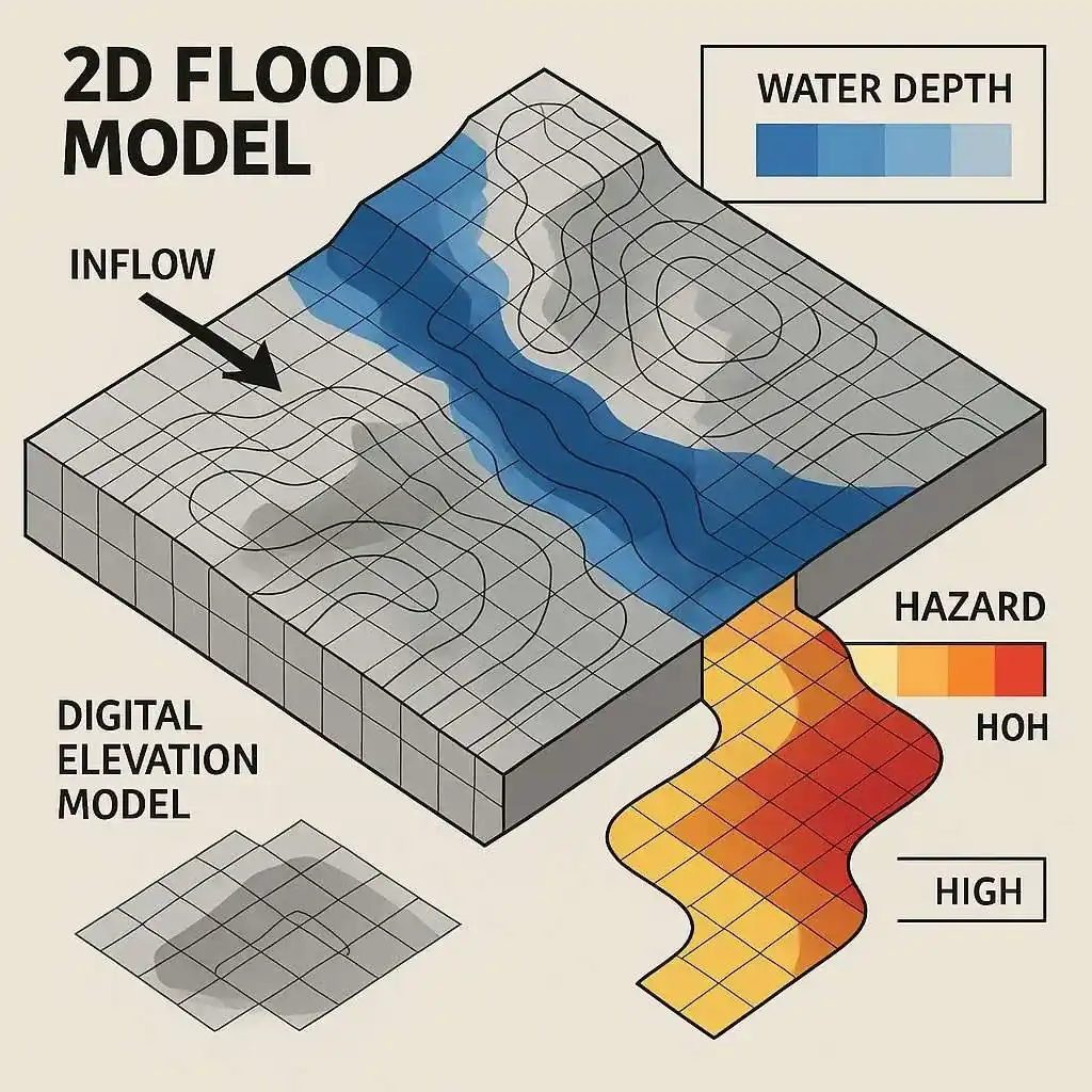
2D flood mapping generates a digital terrain flood map including the river/channel, the floodplains, and structures around the area. A grid is then created over the entire area, composed of cells. Each cell of the grid calculates the depth and velocity of flood water. 2D flood modelling is 2-directional, and water can flow in any direction.
This model requires:
- High-resolution terrain data.
- Boundary inflows or rainfall data.
- Roughness of the surface.
- Hydraulic structures.
This model is computationally heavier and requires more data. Often, times 1D/2D hybrid model is used to analyse the flow inside the river channel by 1D and floodplain terrain, and simulation of water spreading in all directions by 2D. This approach is used by Rida reports for flood river modelling. We specialise in building a 1D river network from survey data and pairing it with a 2D flood plain mesh. This gives us a complete flood regime showing the behaviour of the flood both in-channel and on the flood plain.
3D Flood Model
This is a more complex, computationally challenging, and less-used flood model in developmental projects. This model performs the Navier-Stokes equation via a 3D grid to represent currents, turbulence, and vertical flow. This model is used for research purposes or when hydraulic or tunnel flow details are required.
Applications of Flood Mapping in the UK
Flood modelling is used all across the UK to manage flood risk in many ways:
- Urban planning and building design: England uses the Environment Agency’s flood map for planning, which is an official map made through a hydraulic model. But the thing is, this map provides a broad overview and not an in-depth, site-specific, and ground-level analysis. Flood modelling is done for flood risk assessment in zones 2 and 3 for planning permission. Flood models provide all the details one needs before developing an area in England, including flood probability, flood behaviour, and mitigation strategies.
- Emergency response and planning: Emergency services plan evacuation and decide emergency routes using flood modelling. They run worst-case scenarios to identify areas unsafe to use during a flood.
- Insurance and finance: Insurance sectors use the official flood map and flood modelling to assess the possible probability and severity of floods to calculate insurance premiums. Even the flood Re-scheme in England also relies on the same methods to cover high-risk flood areas.
- Climate-change adaptation: Flood models can play a key role in planning for climate change. For example, engineers can include heavy rainfall or higher sea levels to study their effects on specific areas. As a matter of fact, the UK planning guidelines specify climate-change allowances (e.g. +20% rainfall) to use in flood models.
1D vs 2D Flood Model: Which is the Right Model for Your Project
Deciding between a 1D and a 2D flood model completely depends on site properties and project requirements. A simple rule of thumb is, if the length of a flood plain is 3 times more than the width, you use a 1D flood model. But if it is a complex channel and water is moving in an outward direction, you shift to a 2D model. Most professionals begin with a 1D model and shift to or pair a 2D model when the complexity of the project increases
1D flood modelling is cheap and appropriate for simple linear studies. Whereas 2D flood modelling requires high computational power and detailed data, but obviously, at the same time, it gives high-quality two-directional outputs. Most projects nowadays use a hybrid 1D/2D flood modelling approach for detailed analysis and planning permission.
How Rida Reports Create Flood Models
At Ridas Reports, we cover everything from data gathering to final reporting for flood modelling:
- We begin with an initial assessment, where we use existing data, such as ea flood map and river flow records. The site is reviewed as well and compared with the existing data to identify any gaps, like a missing topographic survey.
- In the next step, we gather data to be used as input for the model. The data includes river gauge data, rainfall records, and structures( bridges, culverts, weirs)present on site.
- After gathering data and analysing everything, we move to the flood model setup, where we decide which model will work best for a particular project: a 1D, 2D, or a 1D/2D hybrid model.
- In the next step, professional software systems are used, and a hydraulic flood model is assembled.
- Then we move to the most important step, calibration/validation. In this step, the flood model is compared with historical floods and gauged events. Roughness and losses are adjusted so the model produces real events accurately. We make sure the model is calibrated, because only a calibrated model is a successful model.
- Then we run different simulations, for example, a 1-in-100-year storm + climate-change allowance, using high-performance computers.
- The outputs are analysed to extract flood extents, depths, and velocities.
- The last step is reporting, where we provide a technical report to the client with flood maps, depth/velocity tables, scenario summaries and modelling assumptions.
Our 2025 Flood Modelling Report– Rye Common Lane, Crondall (Surrey)
In July 2025, we performed a hydraulic assessment at Rye Common Lane, Crondall, Farnham, Surrey. This assessment was done to analyse how this area will behave under different flood events and climate change.
What did we do?
- Our engineers used FEH Web Service’s catchment data to calculate the drainage area, which was 2.37 km². Then we performed different storm simulations using the ReFH2 model, such as 1-in-20, 1-in-30, 1-in-75, 1-in-100, 1-in-200, and 1-in-1000-year events.
- Since heavy rain due to climate change is expected, our engineers uplifted the 1-in-100-year event to 14% 23% and 1-in-1000-year to 14%
What were the results?
- Our results showed an increase in peak flow due to return flow.
- Summer storms created the strongest flow.
- For example, the peak flow of a 1-in-100-year event was 2.67 m³/s, which went up to 3.45 m³/s due to a 23% climate uplift.
Final Verdict
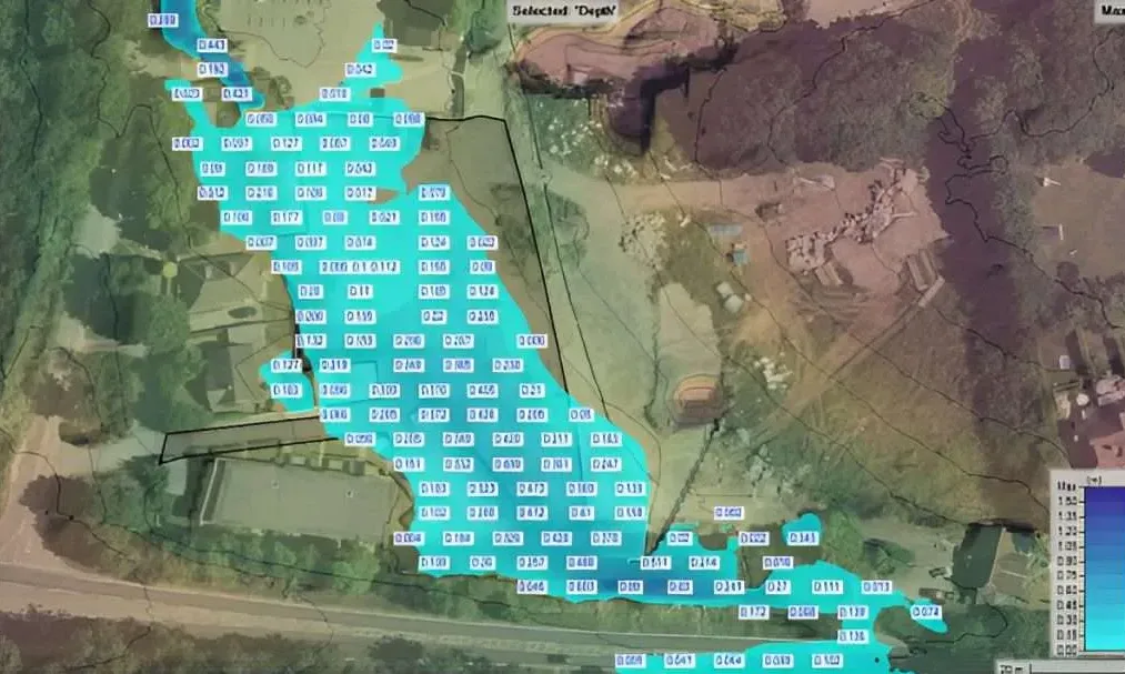
Figure from the original report – Flood Inundation Map (1 in 100 year)
The detailed hydrological outputs show that the location is not safe for development. In the worst-case scenarios, all culverts will block, and flood levels are expected to increase by 0.08 m to 0.68 m during a 1-in-100-year event with a 23% climate change allowance. Consulting the council to evaluate potential risks was also recommended.