
Local planning authorities are required to perform a Strategic Flood Risk Assessment (SFRA) to carry out a local plan by the National Planning Policy Framework (NPPF). The SFRA is performed area-wide to evaluate all sources of flood, consider current and future changes, and include climate change.
This process must be understood by anybody drafting a land-use change, redevelopment proposal, or planning application.
This blog will cover everything about strategic flood risk assessment, including why it is essential, how it shapes development decisions, the difference between Level 1 and Level 2 SFRAs, how it supports the Sequential and Exception Tests and why many developments additionally require a site-specific flood risk assessment study.
What is a strategic flood risk assessment, and why does it matter?
Local authorities conduct a comprehensive analysis called a strategic flood risk assessment (SFRA). Strategic flood risk assessment helps councils determine which property is safe for development and pinpoints locations where floods may occur.
Councils are unable to create local plans or make well-informed decisions on the locations of residences and businesses without a strategic flood risk assessment.
What does it include?
A modern strategic flood risk assessment covers:
- Flooding from rivers
- Flooding from the sea
- Flooding caused by surface water
- Flooding caused by groundwater
- Outlines of reservoir floods
- Historical flooding hotspots
- Problems with local drainage
- Future scenarios and the impacts of climate change
- “Level 1” and “Level 2” strategic flood risk assessments are now prepared by numerous councils.
Level 1- Broad flood risk mapping
Level 2- Detailed analysis for high-risk areas that may still need development
Planners, developers, and local authorities can make well-informed decisions about land use and development by using this information to comprehend the area’s present and future flood risk. Strategic flood risk assessments ensure that new development can be made safe, sustainable, and compliant with local and national planning policies. They do this by combining broad mapping with in-depth, site-specific analysis where risk is higher.
Who Uses an SFRA and How It Influences Decisions
Important planning choices are supported by the strategic flood risk assessment, including
- Which locations are ideal for new housing?
- Where should commercial growth be focused?
- Whether an exception test or a sequential test is necessary
- Which locations need to submit a thorough flood risk assessment in order to plan
SFRA is used by multiple official authorities and influences development and planning decisions. Let us look at them one by one:
Local Planning Authorities
The primary users of strategic flood risk assessment are local councils. Planners and policy makers use it to:
- Allocate land for development, as SFRA flags which sites are flood-free and which carry high flood risk.
- Write flood policies, for example site site-specific restrictions and drainage standards.
- Justify development locations. An SFRA is used to check why an area was chosen and proves that safer sites were prioritised.
In simple words, an SFRA is used as a scorecard and map that shows all available land by flood risk.
The Environment Agency
Next, the Environment Agency utilises a strategic flood risk assessment to advise on local plans and applications. Before a plan is approved, it has to go through EA for consultation.
The EA checks SFRA, ensures it is up to date and according to policy. For example, the EA recently required Enfield’s plan to update its SFRA and insisted that every site must pass the sequential and exceptionals tests.
Developers, Architects, and Homeowners
Developers check an area’s strategic flood risk assessment before buying land. As if the land is in a high-risk area, it might be hard to build on or not allowed at all. Architects utilise an AFRA to design the development risk-free, and designers use the map to avoid placing important parts of a building in a high-risk zone.
Even though strategic flood risk assessment is mainly a planning document, homeowners can use it when selecting an area for housing. A high-risk flood area is likely to face expensive insurance,
SFRA Level 1 and Level 2 Explained
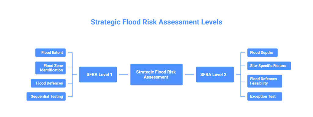
There are two levels of strategic flood risk assessment. Generally, a level 1 strategic flood risk assessment is performed, which decides whether a level 2 strategic flood risk assessment is required.
SFRA level 1 is a broad screening that uses existing maps and all flood sources to check:
- What will be the possible extent of the flood
- Identify the flood zone of each allocation.
- Pinpoint flood defences and infrastructures
- Perform early sequential testing to identify low-risk areas.
If SFRA level 1 predicts that most of the development can lie in a low-risk-free zone and avoids the flood plain, no further level 2 SFRA is required. But if the level 1 SFRA shows that most parts of the development can not avoid high-risk flood zones or the area itself is in a high-risk zone, it is mandatory to move to Level 2 SFRA.
SFRA 2 is a more detailed assessment that covers:
- Flood depths, velocities and hazards on high-risk sites
- Include site-specific factors, like minor topographic variations.
- Assess if it is possible to make a site safe with flood defences
- Provide evidence of passing the exception test, where the sequential test alone was not enough
The Legal Value of a Strategic Flood Risk Assessment
A strategic flood risk assessment is not optional, but rather a legally mandatory requirement for a local plan to gain development permission. The National Planning Policy Framework requires local plans to be supported by an up-to-date SFRA.
The NPPF and government advise to prepare an SFRA in consultation with the Enviroment Agency. Additionally, a strategic flood risk assessment needs to be up to date. A planning inspector will expect recent SFRA data, and if the evidence is out of date, the plan can face delays.
The Enviroment Agency relies on SFRA to analyse drafts and applications. An application without an SFRA document or a weak SFRA is likely to face objections, delays and sometimes rejections.
How SFRA Informs the Sequential Test and Exception Test
During strategic flood risk assessment, the main goal is to identify the lowest flood risk zone and show that in a plan, flood risk-free zones are prioritised. This is called a sequential test, which is performed to find the lowest risk zones and prioritise them for development.
Kindly note that, during sequential testing, artificial flood defences are completely ignored. For example, if an area is in flood zone 3 but has a flood wall, it will still be considered a high-risk zone. This is done to avoid false security.
If, after initial screening and sequential testing, some development still lies in high-risk zones, then an exception test is performed. An exception test is performed to prove
- This development will provide wider sustainability benefits.
- The proposal will be safe from flooding for its lifetime.
Sequential and exception tests are an important part of strategic flood risk assessment. One proves safest sites are prioritised, and the other proves high-risk zone is sustainable, beneficial and protected from flooding.
What is included in a flood risk survey?
A typical flood risk survey includes:
- Thorough topographic analysis
- Inspection of drainage systems (public and private)
- Analysis of the surface water flow path
- Observations of groundwater
- Risk assessments for several sources of flooding
- Design suggestions to maintain the site’s security.
Flood risk assessment for planning applications
How development design is enhanced by strategic flood risk assessment findings:
Strategic flood risk assessment data is used by developers to create long-lasting, safer structures. For example:
- Raising the floor levels above the anticipated flood levels
- Using water-resistant materials
- Adding barriers to redirect floodwater
- Improving drainage around the site
- Establishing pathways for emergency access
- Sustainable drainage system (SuDS) installation
These steps lower future maintenance costs and help comply with planning regulations.
Strategic flood risk assessment vs site-specific flood risk assessment
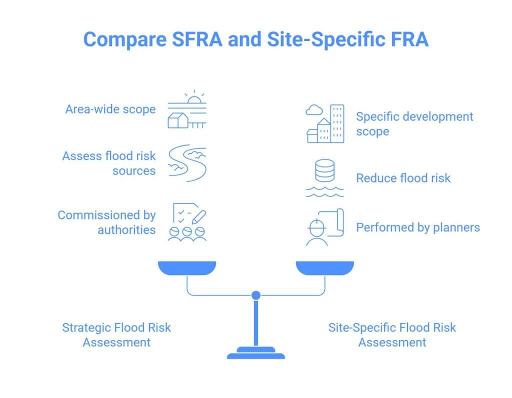
It is normal to confuse strategic flood risk assessment with site-specific flood risk assessment, but they both serve different purposes. An SFRA is conducted on an area-wide basis, whereas a site-specific flood risk assessment is conducted for a specific development.
Comparison table: Strategic flood risk assessment vs site-specific flood risk assessment
| Aspect | Strategic flood risk assessment | Site-specific flood risk assessment |
|---|---|---|
| Purpose | Guide planning decisions | Support individual planning applications |
| Scale | Town/city wide | Property-level |
| Detail | Broad | Highly detailed |
| Includes surveys | No | Yes |
| Includes drainage checks? | General info only | Detailed inspection |
| Consider land levels? | Approximate | Accurate survey |
| Used for approval | Policy tool | Required evidence |
Real-world example: Flooding insights from Basingstoke
How RIDA Reports Support Flood Risk Assessment in England
Flood risk assessment is an important part of any development in England. Local plans require strategic flood risk assessment, and particular projects require site-specific flood risk assessment.
As a home owner or planner in England, you also need expert help for a full site-specific flood risk assessment that may never face rejection or objections and is always up to date with England Policies.
Our engineers at RIDA perform EA-compliant flood risk assessment, and not only that we also make sure it includes error-free mitigation strategies. We cover all sources of flooding and perform 1D and 2D flood modelling, so everything is covered.
Frequently Asked Questions
A high level study carried out by a local government to determine flood threats throughout its territory is called a strategic flood risk assessment(SFRA). It serves as a reference for planning decisions by highlighting places that are favorable for development and those that are vulnerable to flooding from rivers, the coast, surface water, or groundwater. In accordance with UK planning guidelines, the strategic flood risk assessment also assists councils in applying the sequential test and exception test.
As we know, climate change and flood data keep changing and updating, so it is important to keep the SFRA updated with these changes. Common triggers for SFRA update are:
- Local plan review or a new plan is prepared.
- When the government updates climate change allowances.
- When the Enviroment Agency updates flood maps and flood models.
- When a major flood incident occurs, or a new major flood defence is built.
You may also need to update the strategic flood risk assessment if many planning applications in the area are facing options or new FRA requests.
A detailed flood risk assessment report is required when:
- A development lies in flood zones 2 or 3
- A structure larger than one hectare is suggested,
- The chance of surface water flooding is high
- Groundwater issues are shown in the strategic flood risk assessment
- More proof is needed for (planning practice guidance)
- A chance of use increases vulnerability
An SFRA ensures that flood risk is properly factored into planning decisions and helps steer development away from high-risk areas, supports evidence-based policies, and reduces future flood damage and costs.
Usually, strategic flood risk assessment begins with Level 1, which assesses the whole area to determine in which flood zone most parts of the area lie or what the general flood risk of the area is.
If level 1 shows most developments won’t be able to avoid flood zone 2 or 3, or most areas are high-risk zones, level 2 SFRA is performed. It covers flood depth, hazards, mitigation strategies and sustainability benefits.
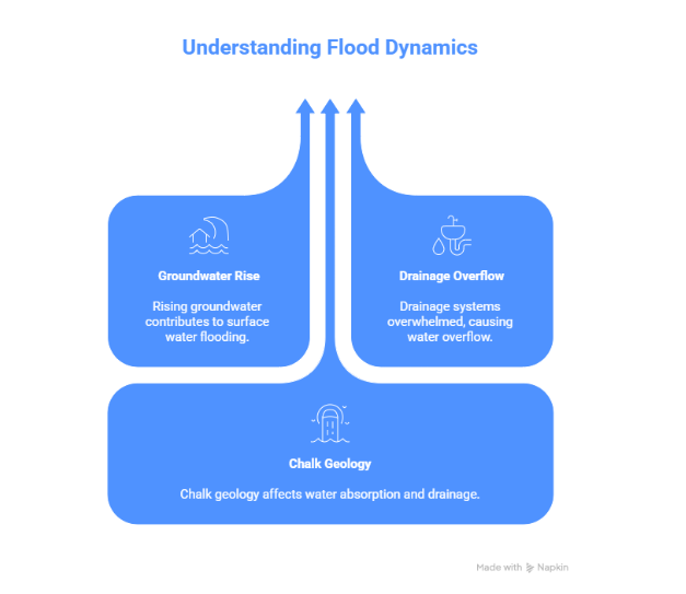
Although they are not flawless, flood risk models offer accurate estimations. Because of surface water ponding, groundwater rise or drainage problems, flooding can occur anywhere, not only along rivers or the coast.
To conduct a flood risk assessment, you identify all potential flood sources, review maps, and local flood history, assess the likelihood and consequences, map potential flood areas, and recommend measures to reduce risk, such as raising floor levels or adding drainage solutions.
The main objectives are to keep people and property safe,reduce flood risk, guide development to the lowest-risk areas, and provide evidence for planning authorities to make informed decisions.