The new proposed 2026 national planning policy framework (NPPF): impact on flood risk, viability, and design
The draft 2026 NPPF (December 2025 publication date), represents a shift in flood risk planning policy.
For developers and architects, the message is clear;
- Drainage becomes an integral part of the design process
- Updated national flood mapping is already affecting site delivery, meaning many developments may require a Flood Risk Assessment before planning decisions are made.
This article outlines the potential impact of the proposals in practice and what should be done now before the final policy document is published in Summer 2026.
A More Predictable System – at a greater cost before planning approval
The draft NPPF moves toward a rules based system. While this provides developers with certainty, the need for earlier technical work will bring increased costs before planning approval and land value is determined.
Therefore, if adopted as drafted, some sites which were previously deemed viable will no longer be viable.
This is especially true for brownfield sites within urban areas. Urban brownfields are a key area for development due to their location however, many urban brownfields present complex drainage problems.
In addition to the use of updated flood mapping, this presents a new layer of viability risk for these types of projects that was not present in the previous regulatory environment.
Viability issues: rigid margins and increasing Costs
One of the key aspects of the proposed regulation is the adoption of standardised viability inputs.
This includes a developer’s return of 17.5 % gva plus affordable housing at a separate 6% margin.
The purpose behind this provision is to limit the developer’s ability to negotiate lower planning contributions due to higher-than-normal costs.
From a flood risk perspective, the introduction of this provision creates an additional problem. The costs associated with providing drainage solutions (i.e., complex SuDS, land raising, etc.) must now be included in the initial land bid.
Therefore, while there may be opportunities to increase these costs after the fact, there will be very little opportunity to recover them.
As a result, developers are presented with two primary variables:
- the amount of money spent purchasing land
- the number of units of affordable housing provided
On projects that include high flood risk constraints, this situation may lead to either decreased viability or eliminate the possibility of project delivery.
This pressure will likely be felt most acutely by small/medium-sized enterprise (SME) developers due to their inability to bear the high upfront technical costs prior to receiving planning certainty.
Design begins with drainage
The proposed regulation effectively eliminates the common practice of developing a scheme design then working out how to fit in drainage afterwards.
Instead, drainage will be included at the start of the design process.
To achieve this, developers will need to develop a highly integrated process between engineers, planners and designers from day one.
Additionally, the proposed regulations will require significantly more professional involvement prior to submitting a planning application.
The SuDS hierarchy will play a central role in this new methodology:
- Rainwater harvesting
- Infiltration
- Surface water Discharge into water bodies
- Discharge to sewer (last resort)
Each step down the hierarchy must provide justification for why it cannot be avoided.
Therefore, discharging to sewer will no longer be an option unless all other alternatives have been shown to be impossible.
Space for water is now mandatory
The proposed requirement to intercept the first 5mm of rainfall onsite prior to allowing Discharge, adds even more pressure on developers.
Practically speaking:
- a 1ha site = 50 m³ of water
- a 10ha site = 500 m³
While these amounts represent relatively small volumes, they still require space and therefore must be incorporated into the design from the beginning.
Due to high density urban environments, developers will need to find increasingly creative ways to incorporate green roof systems and permeable surfaces and integrate these into their overall landscaping drainage systems.
Green roof systems and permeable surfaces are no longer optional extras – they are now core elements of your design.
Additional design considerations: culverts & long-term maintenance
The proposed requirement to assess existing culverted watercourses and restore those that are not functioning properly, introduces yet another layer of complexity.
Culverts can both hinder flow and exacerbate flooding. Restoring culverted water courses can improve flow rates and potentially reduce flood risk — but restoring culverts can have significant impacts on layout, levels and available open space.
Additionally, developers will need to demonstrate a commitment to long term maintenance.
Change to flood mapping to include climate change
There is currently an even greater threat to development than the Draft National Planning Policy Framework (NPPF): the introduction of NaFRA2 flood mapping.
This new national dataset has significantly changed flood maps across England. Many previously mapped flood areas have been moved up in risk.
It has become evident that NaFRA2 was developed using a strategic approach.
Therefore, it would appear that its use at a site level could lead to planning inconsistencies.
Additionally, while many developers continue to work with flood risk data which they know is not complete, nor likely accurate, changes to the data can further exacerbate issues.
These concerns create uncertainty, not only regarding programme but also cost.
Oxford Case Study – How Changes in Mapping Can Affect Viability
One example of how this issue has affected the viability of developments in the UK is a recently completed scheme in Oxford. A proposal for 18 units of affordable housing had initially been classified as being located within Flood Zones 1, 2, 3a, and 3b by the previous national flood mapping dataset.
Notably, the developer questioned why their development was placed in Flood Zone 3b according to the new NaFRA2 dataset, when there was a flood alleviation scheme built approximately seven years prior to the submission date.
Unfortunately, the local authority made it very clear that planning decisions must rely solely upon the results of the national datasets. Three possible courses of action were identified:
- to refine levels through detailed topographic survey,
- to undertake hydraulic modeling to dispute the flood mapping data,
- to redesign the scheme so that it did not include Flood Zone 3b.
Each course of action requires additional cost, time, and/or risk.
For developments where the entire project is intended to provide affordable housing; absorbing such costs becomes increasingly difficult.
Under the proposed viability guidelines, if a similar development were privately funded, it would most likely be abandoned.
Again, this is not a singular instance. Rather, it illustrates a larger problem.
There is a growing disconnect between what the national mapping provides and what happens on individual development sites.
Action You Must Take Now
The final version of NPPF should be released summer 2026. Upon release, it will automatically be applied to all pending/undecided applications.
You therefore have a limited amount of time to take action.
- Check flood risk at your active sites now
Examine the present flood Risk Map to determine if you have any properties that fall within high-risk flood zone boundaries. Check the location of the development within flood zone 3 b. See our maps to do this.
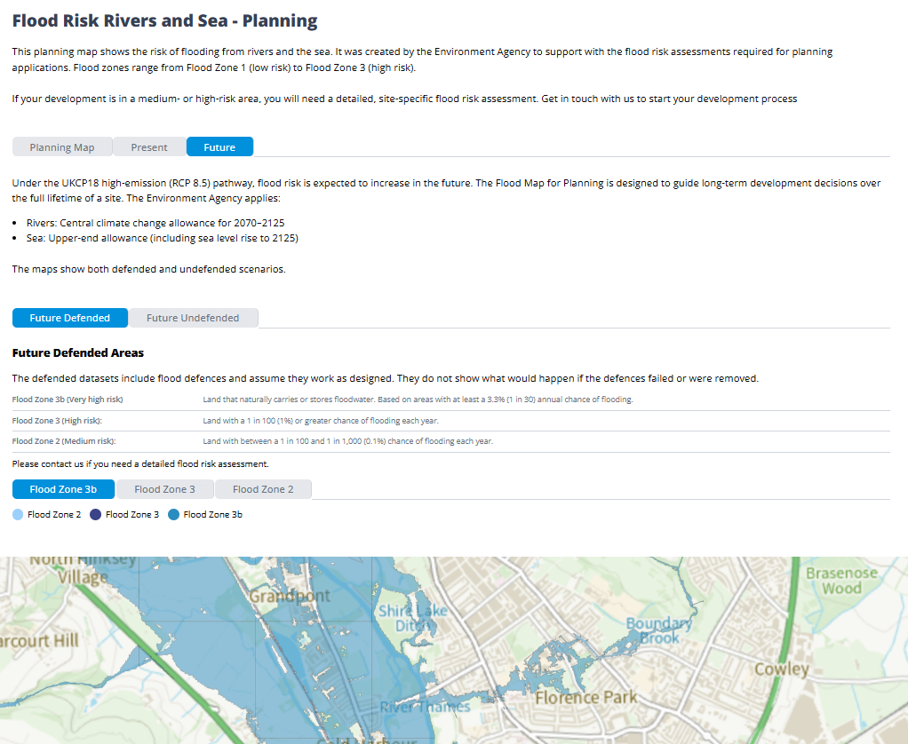
If you do have some property which falls near those boundaries then order surveys as soon as practical.
- Evaluate your design drainage strategy against the proposed standards
SuDS standards published in 2025 are already beginning to influence planning decisions. Developers whose designs fail to achieve compliance with the proposed standards will encounter problems during the planning phase.
- Start engaging with Local Planning Authorities (LPAs), and Local Lead Flood Authorities (LLFAs), now
Flood risk and drainage have moved to the forefront of the planning process. As such, early engagement reduces risk down the line.
The revised version of NPPF slated for summer 2026 will not alter direction – rather accelerate it. Flood risk will no longer be viewed as strictly a technical item to be resolved late in the development process.
Need help understanding how the proposed NPPF changes affect your development?
Our Chartered Engineers can advise whether your project requires a Flood Risk Assessment, or Drainage Strategy, before you submit your planning application.
Frequently Asked Questions
Location and local conditions determine risk. Use GOV.UK. postcode tools to assess the long-term flood risk from surface water, rivers, and the sea.
- Prioritise safety
- Move valuables to higher ground
- Follow flood warnings and official guidance
- Contact insurers and local authorities after the flood
Storms are constantly updated by MET (Meteorological Office). Check live forecasts and flood warnings to stay prepared.
Rivers overflowing, coastal surges, heavy rain, groundwater rise or unexpected flash floods can all result in flooding.
A flood risk UK postcode check provides a general overview based on national flood models. It shows the likelihood of flooding from rivers, the sea, and surface water in the surrounding area. However, it does not assess individual property features, drainage systems, or site-specific mitigation measures, which may require a detailed flood risk report.