A flood risk assessment is needed as part of planning applications for planning permission in England. An FRA includes information about the flood risk of a site based on flood sources, climate change and flood models.
It also includes mitigation strategies and proof that development in a specific site will not increase the risk of flooding elsewhere.
A simple rule of thumb is that if your site is located within the flood zones 2 or 3 or the functional floodplain (Zone 3b), a flood risk assessment is mandatory.
This blog will explain:
When an FRA is required in England
What is the purpose of the FRA
Consequences of ignoring an FRA
What are the essential components of an FRA
How to find the best flood risk assessment services in England.
The scope and complexity of a flood risk assessment will vary depending on the type and scale of development, as well as the flood zone classification. For a detailed breakdown, see our guide to flood risk assessment cost, including typical pricing for different project types.
When is a Flood Risk Assessment Compulsory?
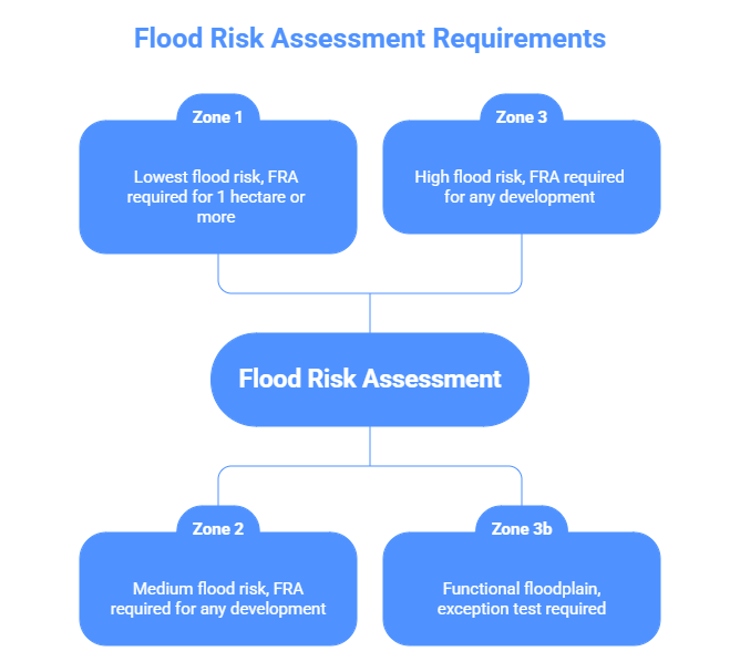
The main factor which determines the need for a flood risk assessment is the site’s flood zone location. Basically, the Enviroment Agency classifies the area of England into three flood zones. Zone 1 has the lowest flood risk, and Zone 3 has the highest flood risk. If your area comes under zone 2 or zone 3, you are asked to submit an FRA for planning permission.
For sites located in Flood Zones 2 or 3, planning authorities may require additional assessments to justify development. One of the key requirements is the sequential test for flood risk, which ensures that development is directed to areas with the lowest probability of flooding. This is often a critical step in securing planning permission.
Flood Zone 2: Regardless of the extent of the property, any development proposed within this zone requires a flood risk assessment, as this zone covers land with a medium probability of flooding and an annual river flood between 0.1% and 1%.
Flood Zone 3: This zone has an elevated flood risk, as it has 1% annual chance of river flooding and a 0.5% chance of coastal flooding. Projects within this flood zone must be supported by an FRA and are subject to rigorous planning standards.
Flood Zone 3b: Developments within the functional floodplain are required to submit an exception test, being the land with the highest risk of flooding and consequently a lower chance of planning permission.
When Flood Zone 1 Requires an FRA
Generally develppment in Flood Zone 1 does not require an FRA. But, if the land is 1 hectare or bigger, an FRA will be required for planning permission.
Consequences of ignoring an FRA
If a planning application does not include a flood risk assesment can result in serious consequences like refusal or delay.
Refusal of Planning Permission: If the Local Planning Authorities (LPA) identify any lack of information or unsatisfactory data in your planning application, they can deny your application under planning policy terms.
Appeals and Delays: Appeal in case of refusals to the Planning Inspectorate and the Secretary of State can take months. And it does not guarantee a decision overturn and is costly.
Sequential and Exception Tests: In the case of development in a high-risk flood zone, the flood risk assessment can trigger a sequential test, and a sequential test can further trigger an exception test. Flood risk assessment is not just a policy; it is a protection for the people of England. So, ignoring FRA and its essential components not only affects your planning application but also puts your safety at risk.
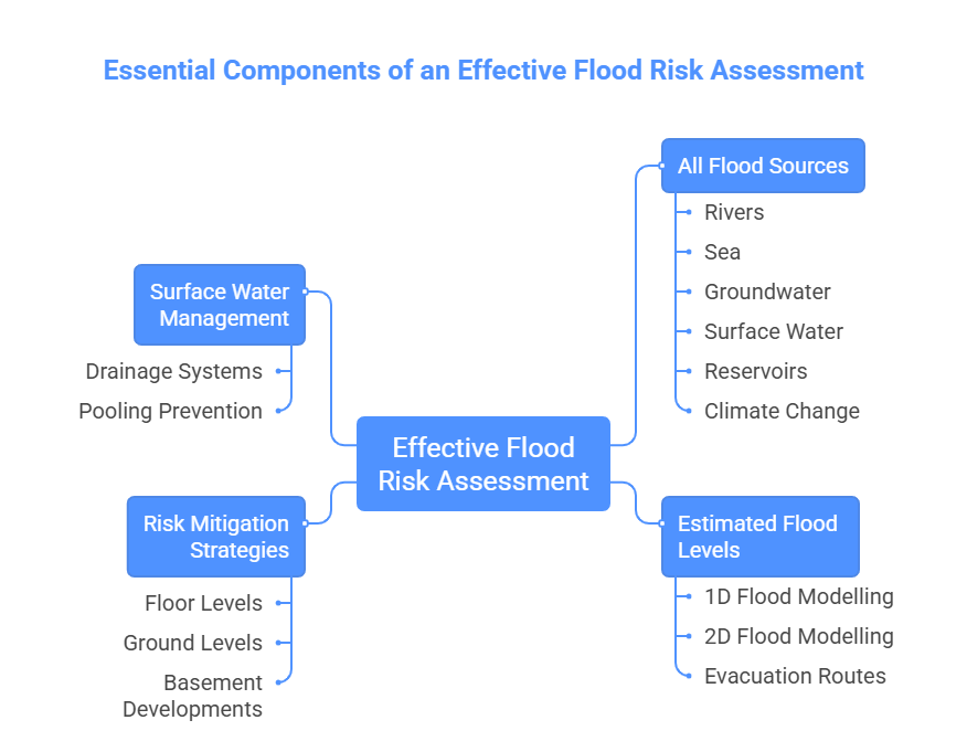
An effective flood risk assessment report must include:
All Flood Sources: A flood risk assessment includes flood probability data from rivers, the sea, groundwater, surface water, reservoirs, and climate change allowances. Flood risk assessment from all sources builds a strong foundation for planning permission and flood protection.
Estimated flood levels: Professionals, such as RIDA Reports, perform 1D and 2D flood modelling to predict flood levels, depth, and direction. Flood modelling also helps in pinpointing safe evacuation routes in the risk mitigation strategy section of an FRA.
Risk Mitigation Strategies: An effective flood risk assessment also includes flood risk mitigation strategies after analysing the flood risk of a site. It includes predicting floor and ground levels, skipping basement developments in high-risk zones, etc.
Surface Water Management (SuDS): If development faces surface water flood risk, the flood risk assessment report will also recommend surface water drainage systems to prevent pooling of heavy rainfall water and prevent it from turning into a flood.
Who Should Prepare the Flood Risk Assessment?
An experienced expert should performa flood risk assessment. Contacting a FRA specialist or consultant ensures a secure planning application, giving confidence that the document you are presenting meets regulatory requirements and reduces the future risk of flood-related issues. Expert consultants prepare detailed hydraulic calculations, climate allowances and breach modelling, typically required, while also advising you on relevant flood risk decisions.
Additionally, this professionals will contact the EA to get more detailed flood data, including information on flood depths and possible defence failures when needed, while it will also check whether extra permissions such as licence for any works within 20 m of a main river or flood defence and other common permissions are required, preventing its client in advance to avoid problems later in the planning process.
We at RIDA Reports have over 20 years of experience in providing different services:
Flood Risk Assessment.
Exception Test.
Sequential Test.
Sustainable Drainage Strategies.
Our engineers perform 1D and 2D flood modelling, and perform different scenarios to check for direction, flow and depth of flood. Our engineers will include all possible flood sources and provide successful mitigation strategies. Our entire process of flood risk assessment follows official flood policies by NAFRA2 and the Environment Agency.
If your development requires a flood risk assessment, working with experienced professionals is essential to ensure compliance with planning policy and avoid delays. Our flood risk assessment consultants can advise on requirements, prepare reports, and support your application through to approval.
An FRA should outline existing flood risks from all relevant sources (river, sea, surface water, groundwater, etc.), assess how the proposed development will affect those risks, and set out mitigation measures to ensure the scheme is safe and won’t increase flood risk elsewhere.
In England, there are two main entities in charge of reviewing planning applications where flood risks are involved. The Environment Agency (EA) and the Lead Local Flood Authority (LLFA). While LLFAs concern on extensive developments affecting local drainage. The environmental agency must be consulted when risk comes from areas with higher flood probability.
An inadequate submission can lead to additional costs, rework and deadlines being pushed forward. By providing a complete FRA from the beginning, you can avoid planning refusals and ensure that the development stays safe throughout its course.
Yes. Minor developments, including house extensions, require a Flood Risk Assessment if they are located within Flood Zones 2, 3, or 3b. Even where the extension is under 250m², a simplified FRA is still necessary for household applications. Additionally, an FRA is mandatory in any location if the proposed works could affect a watercourse, culvert, or existing flood defence.
Conclusion
A flood risk assessment is an important part of planning permission in England. Land in flood zones 2 and 3, also land 1 hectare or bigger in flood zone 1 require a flood risk assessment. A flood risk assessment includes flood risk analysis and flood mitigation strategies.
RIDA Reports provides a flood risk assessment in 48 hours, and they use official flood data from the Enviroment Agency and provide a successful assessment report that ensures planning application approval.