
- Initial Flood Risk Assessments in 48 Hours • Drainage Strategies in 5 Days • Fixed Prices
Flood Risk Assessments for Planning Permission
Chartered engineers delivering flood risk assessment planning ready in 48 hours, compliant with Environment Agency and Local Authority guidance.
October 2026 by Argemiro Rivera, BEng(Hons) MSc CEng MICE MCIWEM C.WEM CEnv

23+
Years of Expierence
Argemiro Rivera, known professionally as Arge Rivera, is a Chartered Civil and Environmental Engineer who has worked in civil and water engineering since 2003.
Looking for Flood Risk Assessments for your planning application?
RIDA Reports is an Oxford-based flood risk and drainage consultancy of chartered civil engineers, founded in 2017 and led by Argemiro Rivera, BEng(Hons) MSc CEng MICE MCIWEM C.WEM CEnv. Our flood risk assessments for planning applications are completed by chartered engineers who keep up to date with the latest legislation and flood modelling data, to protect your development from flooding and help it gain planning permission.
Our expertise enables us to provide full range of services for any size development. We are able to create 1D and 2D river models and assess your development within flood zone 2 and flood zone 3, critical drainage areas or in areas where the flood levels are unknown. We can also produce sequential tests and exception tests for your site.
We understand the requirements of the Environment Agency, Lead Local Flood Authorities and local planning authorities, and we work with them to help your development gain planning permission.
Flood Risk Assessment Reports and Fixed Prices
Join the hundreds of architects, planners and developers who are using responsive technical data and clear engineering judgement to get their developments underway.
RIDA Reports by the numbers (October 2025 - October 2026):
Updated quarterly.
Data verified by Argemiro Rivera, BEng(Hons) MSc CEng MICE MCIWEM C.WEM CEnv
| Report | Fixed price | Applies to |
|---|---|---|
| Flood Risk Assessment – Extensions and Change of Use | £750 | Developments less than 250 square metres within Flood Zone 2 or 3 |
| Flood Risk Assessment – Single Dwelling | £800 | Developments less than 1,000 square metres within Flood Zone 2 or 3 |
| Flood Risk Assessment – Minor Development | £950 | Developments less than 2,500 square metres within Flood Zone 2 or 3 |
| Flood Risk Assessment – Major Development | £1,250 | Developments under 5,000 square metres within Flood Zone 2 and 3 |
| Flood Risk Assessment – Strategic Development | £1,900 | Developments up to 50,000 square metres within Flood Zone 2 and 3 |
| Flood Risk Appraisal | £750 | Any size development: site potential within the floodplain before an investment decision or master plan design |
Data verified by Argemiro Rivera, BEng(Hons) MSc CEng MICE MCIWEM C.WEM CEnv
What affects the price of your flood risk assessment? Read our flood risk assessment cost guide.
Our Clients
Trusted by Fisher German, AKT Planning + Architecture, Planning Potential, Fleming Architects, Divine Ideas Architects and Army Rowing.






What Our Customer Says
Rated 5/5 from 50 verified Reviews.io reviews
We have had the pleasure of working with Arge at RIDA over several years and throughout this time the experience has consistently been very good. What stands out most is their responsiveness - any queries or issues have always been addressed promptly, which has given us great confidence and peace of mind.
We are a dynamic flood risk assessment consultancy with substantial experience in supporting planning applications for sectors such as housing, commercial, recreational, renewables and infrastructure.
Benefits of our Flood Risk Assessments
You receive clear and specific advice which:
Meets national planning policy (the National Planning Policy Framework and Planning Practice Guidance on flood risk) and your local plan’s flood risk policies
Cost-effective mitigation of flood risk
Enables you to make informed changes to the design and achieve planning
Safeguards your development from flooding throughout its lifetime
Our flood risk assessment provides a detailed analysis of multiple sources of flood risk proving specific mitigation strategies that apply to your development.
When Is a Flood Risk Assessment Required for Planning?
A site-specific Flood Risk Assessment (FRA) is the report that shows the local planning authority that a proposed development will be safe from flooding for its lifetime and will not increase flood risk elsewhere. It identifies the site’s Flood Zone, assesses flood risk from rivers, the sea, surface water, groundwater and reservoirs, applies the Environment Agency’s climate change allowances, and sets out mitigation such as finished floor levels.
A site-specific Flood Risk Assessment is required with a planning application when:
The site is in Flood Zone 2 or 3;
The site is 1 hectare or larger in Flood Zone 1;
The site is in Flood Zone 1 on land with critical drainage problems; or
The site is in Flood Zone 1 on land that the local Strategic Flood Risk Assessment or the Environment Agency Flood Map for Planning shows to be at risk of flooding from any source, such as surface water, groundwater or reservoirs.
Source: National Planning Policy Framework (17 August 2026), policy F4, and Planning Practice Guidance: Flood risk and coastal change.
Data verified by Argemiro Rivera, BEng(Hons) MSc CEng MICE MCIWEM C.WEM CEnv
Not every planning application needs a full Flood Risk Assessment. For many small house extensions in Flood Zone 1 with no significant surface water or drainage constraints, a proportionate Flood Risk Screening Note may be enough to support the application.
The benefits of using our flood risk assessments for your planning application
- You receive the first reports in 48hrs. This allows you to register your planning application
- Reduced time and costs associated with delayed planning applications
- Increased chances of obtaining planning permission for your developments
- Helps you make design decisions based on detailed knowledge of flood risk mitigation and interventions
- Fixed price for all our flood risk assessments
- We support you through the planning application until a decision is made
- For householder developments and extensions, assessments are prepared proportionately, focusing on the specific flood risk considerations relevant to the scale of the proposal.
When would you get your flood risk assessment?
You will get the initial flood risk assessment in 48hrs. You can validate your planning application right away if you have a tight timescale. You can also use this report to inform your design team of the possible flood risk constraints and resilience measures. Urban Water is RIDA Reports’ sister business.
The final flood risk assessment report can take up to 25 working days, because the Environment Agency has a statutory response time of 20 working days for flood data requests. In some cases we obtain the data within 3 weeks, depending on the Environment Agency’s workload.
During this process, we keep the design team up to date on the findings and liaise with the relevant agencies to make sure your development gets the best chance to obtain planning permission.
Our Flood Risk Assessment Methodology
Written and reviewed by Argemiro Rivera, BEng(Hons) MSC CEng MICE MCIWEM C.WEM CEnv, known professionally as Arge Rivera, is a Chartered Civil and Environmental Engineer who has worked in civil and water engineering since 2003, at RIDA Reports. Over 23 years of engineering experience, drainage design and data management. Last reviewed October 2026. View profile →
RIDA Reports’ flood risk assessment methodology is based on obtaining the best possible data and applying our chartered engineers’ judgement and experience to get your development through planning.
During this process, we are proactive in giving you proven solutions to flooding and are available to discuss design approaches that architects or designers may have.
The flood risk assessment methodology includes
- Obtaining your development’s drawings and levels
- Consulting the available databases and obtaining all relevant flood risk information
- Liaising with the Environment Agency and local planning authorities to understand their requirements
- Agreeing the climate change allowance for your flood risk assessment with the Environment Agency
- Evaluating the detailed flood risk information for river, sea, groundwater, run-off, reservoirs, and critical drainage areas
- Providing clear advice on how to mitigate the risk of flooding
Our civil and structural engineering backgrounds ensure robust solutions that strengthen your planning approval whilst following the Environment Agency standing advice for flood risk assessments.
Reports are written specifically for planning submission and are structured so that planning officers can quickly identify site risk, policy compliance, and any necessary mitigation measures.
What Is Included in a Flood Risk Assessment Report?
Every RIDA Reports flood risk assessment report for planning includes:
- Identification of the site Flood Zone and planning implications
- Assessment of fluvial, surface water, groundwater and reservoir flood risk
- Consideration of climate change allowances where applicable
- Finished floor level assumptions or recommendations
- Proportionate flood risk mitigation measures
- Clear conclusions written for planning officer review
- Design flood level for the 1 in 100 year river flood or 1 in 200 year sea flood plus climate change, and the recommended finished floor level with normally at least 600mm above the design flood level, or 300mm where the flood level is known with high certainty freeboard
- Sequential Test and, where required, Exception Test statements referencing NPPF (August 2026) policies F5 and F6
- Safe access and egress route assessment, and flood resistance and resilience measures (NPPF policy F7)
- Surface water drainage and SuDS in line with the National Standards for Sustainable Drainage Systems (NPPF policy F8), agreed with the Lead Local Flood Authority where required
Worked example: Residential extension in Flood Zone 3a, Oxford
| Site | 130 m² residential site in Oxford, comprising a single-storey rear replacement and infill side/rear extension. Flood Zone 3a. |
|---|---|
| Environment Agency 1 in 100 year plus 30% climate change flood level | 56.325 m AOD |
| Proposed finished floor level | 56.15 m AOD, matching the existing dwelling finished floor level. |
| Mitigation | Flood-resilient and flood-resistant construction, including a tanking membrane up to 300 mm above ground level, fully sealed concrete slabs, flood-resistant materials, services and fittings positioned above 56.925 m AOD where applicable, sealed service entries, closed-cell insulation, resilient floor finishes, non-return valves to new sewer connections, protective walls and flood storage compensation. The compensation fully offsets the flood volume displaced by the development and increases flood storage capacity. |
| Outcome | Planning permission granted by Oxford City Council on 23 July 2026, subject to implementation and maintenance of the flood risk mitigation, flood storage compensation and protective wall measures. |
Our Flood Risk Assessment Maps
Online flood maps are often used as an initial check when considering a development site. However, map data alone is not always sufficient to support a planning application and should be interpreted alongside site-specific assessment where required.
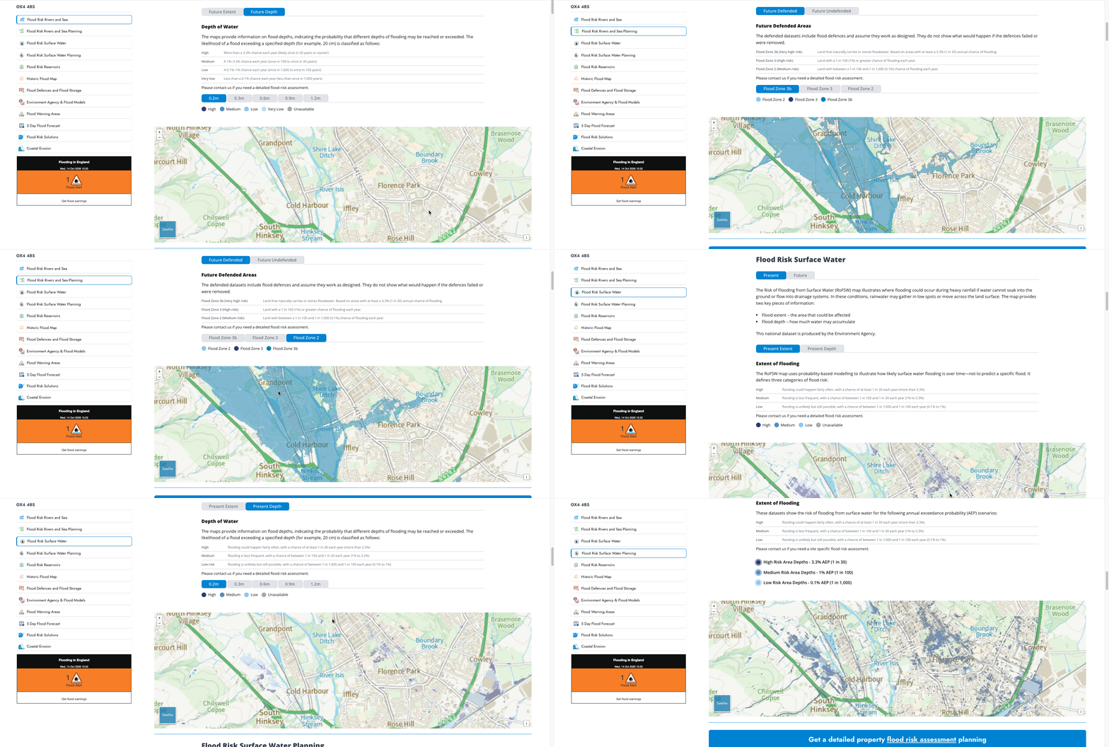
Our flood risk map for planning for England has been developed to check if your development is in a flood zone or affected by other sources of flooding.
You will be able to see the risk of flooding from rivers or sea (planning), flooding from surface water and reservoirs or whether the development is affected by surface water run-off.
We have taken this information directly from the Environment Agency databases and prepared it so you can check in detail if your development needs a flood risk assessment.
You can also check the following maps
- Flood Maps England: Environment Agency Flood Map for Planning
- Scotland: Scottish Environment Protection Agency flood maps
- Wales: National Resources Wales flood map
- Northern Ireland: Flood maps (NI)
Supporting Flood Risk Services for Planning Applications
Every flood risk assessment we prepare is tailored to your site. Depending on site location and planning requirements, it may need to be supported by the additional services below.
Detailed Sequential and Exception Tests
Sequential Test and, where required, Exception Test reports for sites in Flood Zones 2 and 3, prepared with experienced planning consultants to support your planning application.
1D & 2D Detailed River Modelling
Where the Environment Agency holds no flood levels for your site, we build 1D and 2D river models to determine design flood levels and flood depths.
Flood Warning and Evacuation Plans
Site-specific flood warning and evacuation plans that set out how occupants receive flood warnings and leave the site safely.
Flood Risk Mitigation
We provide independent, impartial and professional advice to property owners, developers, businesses and communities wanting to mitigate and reduce the impact of flooding.
Drainage Strategies
Drainage strategy reports by chartered civil and water management engineers, delivered in 5 days and designed to national and local guidance e.g. the National Standards for Sustainable Drainage Systems; e.g The London Sustainable Drainage Action Plan (LSDAP); Local Council Sustainable Drainage Design and Evaluation Guide; CIRIA report C753 The SuDS Manual;
Flood Maps
Check a site’s flood zone and its surface water and reservoir flood risk by postcode on our flood map, built from Environment Agency data.
Our Professional Memberships & Accreditations

Constructionline
- Accredited through Constructionline, verifying our compliance with industry standards for safety, quality, and reliability.

CIWEM
- Recognised for excellence in water and environmental management. Our CIWEM membership ensures all assessments follow the highest professional and environmental standards.

ICE
- As members of ICE, our engineers adhere to rigorous civil engineering standards, bringing technical accuracy, integrity and trusted expertise to every report.

SocEnv
- Our environmental professionals are registered with SocEnv, reflecting our commitment to responsible, sustainable and compliant environmental practice.
Frequently Asked Questions
The National Planning Policy Framework (NPPF) requires a site-specific flood risk assessment for development in Flood Zones 2 and 3, and for some sites in Flood Zone 1 (see 'When Is a Flood Risk Assessment Required for Planning?' above). The assessment shows the local planning authority that the development will be safe for its lifetime and will not increase flood risk elsewhere. The NPPF is supported by the Planning Practice Guidance on flood risk and coastal change, and local planning authorities take both into account when they decide applications. From a planning perspective, Flood Risk Assessments are primarily used by local authorities to confirm that flood risk has been properly considered and addressed in line with policy, rather than to over-engineer minor development proposals.
The local planning authority decides the planning application, and it judges whether your flood risk assessment is acceptable. Before deciding, it consults other bodies: the Environment Agency is a statutory consultee on flood risk from rivers and the sea for many developments in Flood Zones 2 and 3, and the Lead Local Flood Authority advises on surface water for major developments. Which bodies are consulted depends on the size of the development, the source of flood risk and how vulnerable the proposed use is. Many smaller schemes are assessed against the Environment Agency's standing advice without a direct Environment Agency response. You can protect your development by using Nature Based Solutions. Urban Water is RIDA Reports' sister business.
You need a site-specific flood risk assessment if your site is in Flood Zone 2 or 3. In Flood Zone 1 you also need one if the site is 1 hectare or more, has critical drainage problems, or is shown at risk of flooding from any source in the local Strategic Flood Risk Assessment or on the Environment Agency Flood Map for Planning (see 'When Is a Flood Risk Assessment Required for Planning?' above) NPPF August 2026 policy F4 wording. Check your site's Flood Zone on the Environment Agency Flood Map for Planning or on our flood map. For a small householder extension in Flood Zone 1 with no surface water constraints, a Flood Risk Screening Note may be enough. Not sure which report you need? Ask for a free, no-obligation quote.
RIDA Reports issues an initial flood risk assessment within 48 hours of instruction. The final report is normally issued within 25 working days, because the Environment Agency's statutory response time for Product 4 flood level data is 20 working days in some cases we obtain the data within 3 weeks, depending on its workload. The Environment Agency holds the flood level information for all major rivers in England. It runs the hydraulic model for the river and provides a Detailed Flood Risk Assessment Map (Product 4), including flood zones, flood defences, storage areas, areas benefiting from defences, statutory main river designations, historic flood event outlines and detailed river model information. Urban Water is RIDA Reports' sister business.
A hydraulic model is a mathematical model that predicts the likely water levels and flood extent of a river. We build 1D and 2D hydraulic models when the Environment Agency does not hold river levels for your site, so we can determine flood depths and recommend safe finished floor levels. See our river modelling service.
Flood Zones show the annual probability of flooding from rivers and the sea. There are four in England: Flood Zone 1 (Low Probability), Flood Zone 2 (Medium Probability), Flood Zone 3a (High Probability) and Flood Zone 3b (Functional Floodplain). Flood Zone 3a (High Probability) is land with a 1 in 100 or greater annual probability of river flooding (1% or more) or 1 in 200 or greater of sea flooding (0.5% or more). Flood Zone 3b (Functional Floodplain) is land where water has to flow or be stored in times of flood; local planning authorities normally define it as the 1 in 30 year (3.3% AEP) extent. Source: Planning Practice Guidance, Flood risk and coastal change, Table 1 (Ministry of Housing, Communities and Local Government).
You know if your property is in the river flood zone by:
Consulting the Environment Agency flood risk map for planning
Determining if part of the house or development is within the blue area i.e. flood zone 2 or a flood zone 3
Obtaining the property ground levels and river flood levels if you are within flood zone 2 or 3. You can obtain the river levels directly from the Environment Agency
Sending an e-mail to enquiries@environment-agency.gov.uk requesting the Product 4 information. Attach a drawing showing the location of your property and the post code
Determining the levels of your property by instructing a Topographical Surveyor to complete a level survey of your house. The levels must be in mAOD
Comparing the Environment Agency flood levels and your property levels
Your property is in a flood zone 2 or a flood zone 3 if the flood levels are higher than your property levels
We can help you with this process and clearly indicate if your property is in the flood zone. We can also help you determine the best ways to protect your property from flooding.
- Find the property's address and prepare a site location plan or a map link.
- Email enquiries@environment-agency.gov.uk with the period the flooding history should cover and your contact details.
- Pay the charge if one applies ([confirm: current Environment Agency charge; the schema says £25 in some cases]).
- Wait up to [confirm: 20] working days for the report by email.
- In the meantime, ask neighbours whether they have been flooded.
- Check whether local street names refer to rivers, brooks, meadows, moats or other water features.
- Search online for 'flood' plus the street name and postcode.
- Search the local newspaper for 'flood' plus the street name and local authority.
- Check our flood map by postcode.
To find out if you are at risk of flooding in England you could follow these actions:
Consult the Environment Agency long term flood risk from surface water map
Consult the Environment Agency flood risk map for planning
Consult the Environment Agency flood risk from reservoirs map
Contact your local council asking them for the surface water flood maps for your area and about the risk of groundwater flooding. Send an e-mail to either the Highways department or the local Planning office
- The local council can be found on the gov.uk website by using the post code of the property
Send an e-mail to: enquiries@environment-agency.gov.uk requesting the Product 4 information. Compare the river levels against your property levels
It is not possible to determine if an individual property is at risk of flooding from the maps. Your property can be at risk of flooding even if it is on the edge of a flood risk area.
The best way to determine if your house is at risk of flooding is by comparing the flood levels and the levels of your property. You then add the climate change allowance to all these levels.
The Environment Agency publishes peak river flow climate change allowances as percentage uplifts, set by management catchment, allowance category (central, higher central or upper end) and epoch (2020s, 2050s or 2080s). For Oxford City Council's Level 2 SFRA uses the Cotswolds management catchment, the Central allowance for the 2080s is 26% in the south and northwest River Thames catchment, and 15% northeast River Cherwell catchment in our assessments this typically raises the design flood level by between 200mm and 600mm, depending on channel geometry. Sea level rise allowances are expressed in millimetres. Source: Environment Agency, Flood risk assessments: climate change allowances (27 May 2022). Adding the allowance gives a better idea of the depth of a future flood and lets you prepare in advance.
The models are updated every 3 months reviewing engineer checks 'The models are updated every 3 months' and corrects or deletes it and the levels given by the Environment Agency should be taken as guidance only. It is important to recognise that flood events can be higher.
For instance, in England the Environment Agency gives flood levels for design events such as the 1 in 100 year river flood and the 1 in 200 year sea flood, and larger floods can happen. Some countries plan for much rarer events: Other European countries also consider rarer floods. In the Netherlands, Grebbedijk's statutory standard limits annual flooding probability to 1 in 30,000, according to its official flood defence project decision. Extreme flood mapping includes approximately 1 in 1,000 year events in Bavaria, Germany, 1 in 500 year events in Spain, and approximately 1 in 1,000 year events in France. These mapping scenarios are distinct from flood defence protection standards.
We can help you clearly identify the level of risk that your property has and the steps that you can take to protect your property.
Reviewed by Argemiro Rivera, BEng(Hons) MSC CEng MICE MCIWEM C.WEM CEnv, 2026. Regulatory references checked against the National Planning Policy Framework (17 August 2026) and Planning Practice Guidance: Flood risk and coastal change.
Flood zones explained
| Flood Zone | Annual probability (PPG Table 1) | What it means for a planning application |
|---|---|---|
| Flood Zone 1 – Low Probability | Less than 1 in 1,000 (0.1%) from rivers or the sea | A site-specific Flood Risk Assessment is needed only if a Flood Zone 1 trigger applies, such as a site of 1 hectare or more. |
| Flood Zone 2 – Medium Probability | Between 1 in 100 and 1 in 1,000 (1%–0.1%) from rivers, or between 1 in 200 and 1 in 1,000 (0.5%–0.1%) from the sea | A site-specific Flood Risk Assessment is required. The Sequential Test normally applies; NPPF policy F5 exempts some householder and minor development under 250m² and most changes of use. |
| Flood Zone 3a – High Probability | 1 in 100 or greater (1% or more) from rivers, or 1 in 200 or greater (0.5% or more) from the sea | A site-specific Flood Risk Assessment is required; the Sequential Test and, for some uses, the Exception Test apply. |
| Flood Zone 3b – Functional Floodplain | Land where water has to flow or be stored in times of flood, usually the 1 in 30 (3.3%) annual probability extent | Normally only water-compatible uses, and essential infrastructure that passes the Exception Test, are permitted. |
Source: Planning Practice Guidance, Flood risk and coastal change , Table 1. Flood Zones 1 to 3a show the probability of river and sea flooding ignoring flood defences.
Data verified by Argemiro Rivera , BEng(Hons) MSc CEng MICE MCIWEM C.WEM CEnv