

In Wales, flood risk is a major worry for professionals, developers, buyers, and homeowners. When overlapping risk sources are taken into consideration, Natural Resources Wales reported in 2025 that over 2,74,000 properties in Wales are vulnerable to floods. This number is constantly changing as climate change impacts weather patterns and flood modelling.
Wales’ Natural Resources, knowing how to assess flood risk in Wales, use official flood risk data including a flood risk map and take proactive mitigation measures, is crucial whether you’re thinking about purchasing a property, planning development, or need to adhere to planning regulations.
To assist you in accurately assessing and managing flood risk, this dual guide makes use of the most recent Welsh planning policy, official flood mapping tools, and professional techniques.
Understanding flood sources and local responsibility
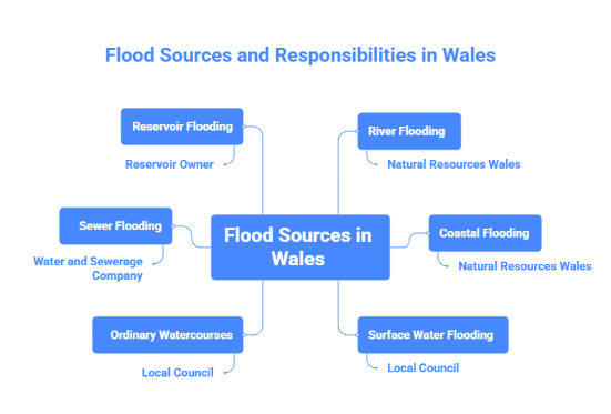
Accurate flood risk management in Wales begins with identifying where the water is coming from and who is responsible for the risk or infrastructure.
Type of flooding | Typical cause | Responsible body |
Main river flooding | Riverside overtopping or defense breach | Natural Resources Wales |
Ordinary watercourse flooding | Smaller streams and ditches overflow | Local council |
Surface water flooding | Heavy rainfall exceeds drainage | Local council |
Groundwater flooding | Saturated soils rising from underground | Local council |
Sewer flooding | Sewer capacity failure or blockage | Water and sewerage company |
Reservoir flooding | Reservoir overflow or structural failure | Reservoir owner |
Road flooding | Poor drainage on roads | Council or trunk road agency |
Immediate flood risk assessment: How to check flood risk in Wales
Using live warnings and postcode flood checks
Natural Resources Wales offers free services to promptly assess your risk of flooding
- Flood risk by postcode: To view the flood danger levels from nearby rivers, the sea, surface water, and reservoirs, enter a postcode in Natural Resources Wales’s “check your flood risk by postcode” tool. To determine whether a location is inside a mapped risk area, these screens are a good place to start.
- Live flood warnings: To assist locals and businesses in keeping an eye on the current risk. Natural Resources Wales releases a 5 – day risk outlook and real-time warnings.
- Floodline: For immediate advice during potential flood events, call Floodline at 0345 988 1188 (Textphone: 0345 602 6340).
Although they are area-based rather than building or land-specific, these techniques provide a first indication of flood risk.
Flood risk assessment Wales (FRAW) map and coastal risks
The flood risk assessment Wales (FRAW) map is a national GIS mapping dataset that incorporates the locations of flood defences and displays flood danger from several sources, such as rivers, the sea, surface water, and tiny watercourses.
Key points about the Flood Risk Assessment Wales (FRAW) map:
- It includes riverine, coastal, and surface water risk layers.
- Flood defences are shown, but defences do not eliminate risk-they merely reduce the probability of inundation.
- Coastal erosion risks are also available through Natural Resources Wales(NRW)’s mapping services
Note: The flood risk assessment Wales (FRAW) map is critical for risk awareness, but does not replace planning stage flood maps. For planning applications, the flood map for planning aligned with Welsh planning policy must be used.
Planning and development:Wales new Technical advice note 15 (TAN 15) framework
The Welsh government updated flood planning policy in 2025 to account for climate change, planning risk thresholds, and new mapping frameworks in Technical Advice Note 15(TAN 15)
Planning a sage screening flood map
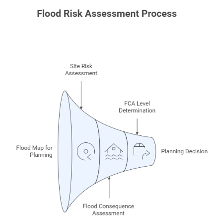
Under TAN 15:
- The flood map for planning is the starting point for planning authorities to decide whether a flood risk assessment is needed. It shows potential flood extents over the design life of developments, including allowance for climate change
- This map has replaced the older development advice maps(DAM) and provide up-to-date flood extent data.
When is a flood consequence assessment(FCA) needed?
- On the flood map for planning, a development site is located in higher-risk flood zones
- Your local planning authority determines that additional assessment is required.
- For sensitive uses, such as residences and care facilities, a thorough planning application is being submitted.
Flood consequence assessment(FCA) reports help in providing that planned development can be implemented safely and without raising risk in other areas.
The three levels of Flood consequence assessment(FCA)
Depending on risk and project size, professionals often operate at three different Flood consequence assessment(FCA) levels:
- Level 1- Screening:
A preliminary desktop study to identify flood sources and general risk.
- Level 2: Scoping:
A qualitative study focusing on impacts and broad mitigation recommendations
- Level 3:Detailed:
A full quantitative analysis, including hydraulic modelling to specify risk levels and detailed mitigation measures.
The choice of Flood consequence assessment(FCA) level depends on location, development sensitivity, and planning authority requirements.
Integrated risk management warning systems for real-time monitoring and flood mitigation.
A multi-tier warning system is operated by Natural Resources Wales:
- Flood alert: Be ready for potential flooding
- Flood warning :Flood is anticipated; immediate action is needed
- Severe flood warning: Life is at risk, take quick action
- Businesses and residents in high-risk locations are urged to register for free flood alerts by phone, email, and text.
Practical mitigation steps:
- Maps are only one aspect of mitigation; another is readiness
- Raised threshold, water-resistant materials, and suitable floor levels are examples of drainage strategies
- Site runoff control and sustainable drainage systems are two drainage options.
- Flood boards, community response plans, and property evacuation routes are examples of emergency preparation
- These steps promote resilience and lessen the effects of flood disasters
Conclusion
Wales has a dynamic and more complicated flood danger due to shifting weather patterns. Knowledgeable planning and expert assistance are essential, whether you are commissioning a comprehensive flood sequence assessment prior to a significant planning submission or conducting a fast flood risk check by postcode.
To match your project with planning standards and improve resilience, start with official mapping, comprehend TAN 15 planning criteria, and make use of expert assessment services ,including those provided by RIDA reports.