
Climate change is changing flooding in the UK, and so the planning rules. The UK government now separates short-term flood risk from long-term flood risk, which can be explored in more detail using a flood risk map. Short-term flood risk is based on 5-day flood alerts, whereas long-term flood risks are based on the probability of flooding over years and decades.
Recent data states that 8 million properties will be at risk of flooding by 2050 in the UK. This has made it vital to check long-term flood risk of a site before any development. This blog is a 101 guide for homeowners in England on how to check long-term flood risk and why is it important to check long term flood risk.
What Is Long-Term Flood Risk?
Long-term flood risk refers to the chance of flooding over an extended period of time, such as months, years, and decades. Long-term flood risks are based on historical data and climate change. On the other hand, short-term flood risks are based on a simple 5-day weather forecast.
In terms of long-term flood risks, even a property with no history of flooding can have a high chance of long-term flood risks if it is situated in a floodplain or low-lying area. Also, long-term flood risk is based on all flood sources, such as rivers, coastal, surface water and groundwater.
How to Check Long-Term Flood Risk in England
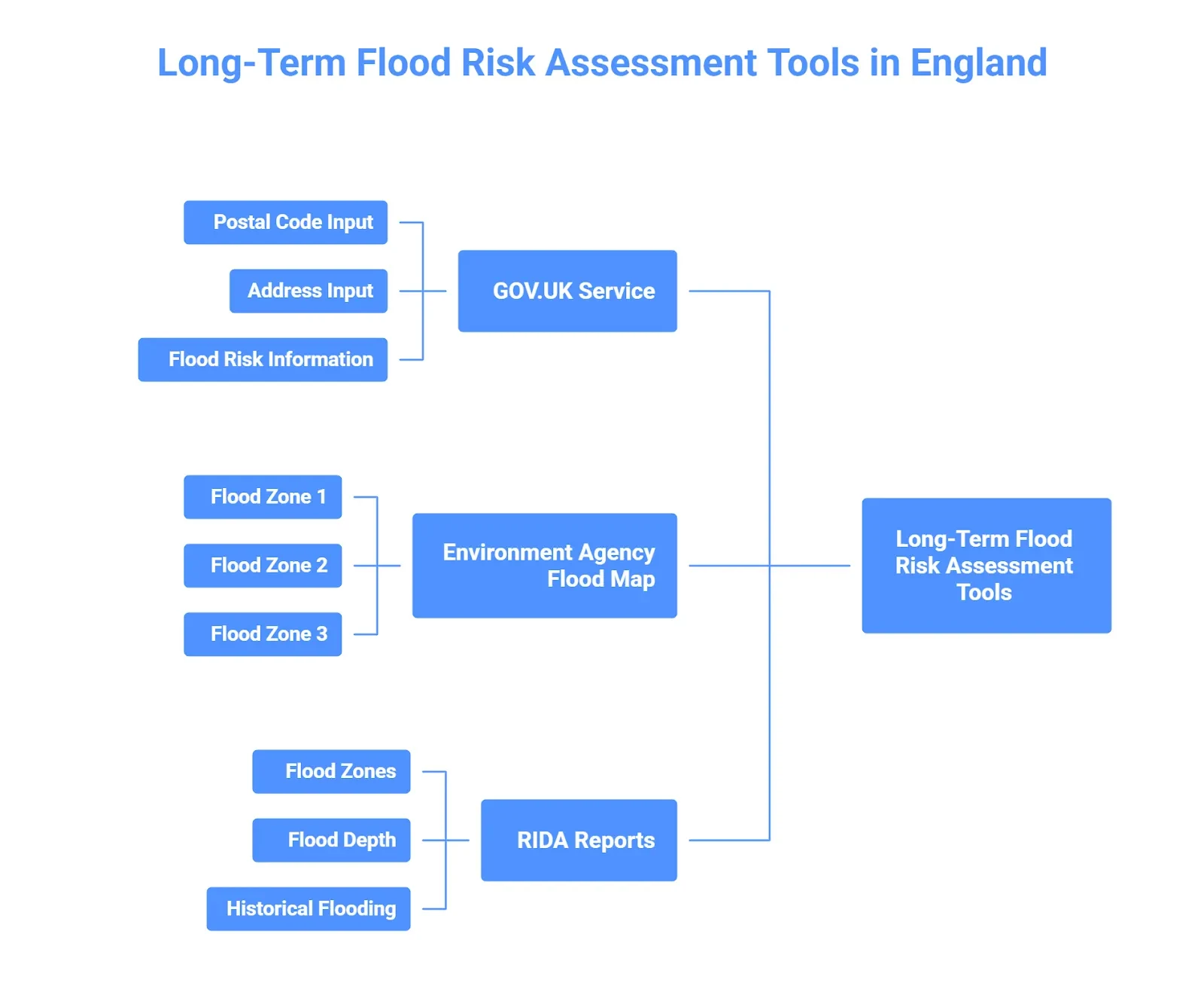
There are a couple of official government tools available to check long-term flood risk in England.
GOV.UK “Check long-term flood risk for an area” service
You can check long-term flood risk in England on the uk.gov official website. The UK.gov provides an online “Check long-term flood risk for an area” service, where you can add your postal code and address to check the long-term flood risk of your area.
This online government tool provides long-term flood risk from:
- rivers and the sea
- surface water
- Reservoirs
- groundwater (where data is available)
You can check your area’s long-term flood risk by following these steps:
- Go to the gov.uk website page.
- Add your postcode
- Then you will be asked to add your address
- You will receive detailed flood risk information from rivers, the sea, reservoirs, surface water and groundwater.
Limitations of the official long-term risk service
This service is up-to-date and authoritative, but it also has its own limitations. The long-term flood risk check service by the UK government does not account for climate change or how flooding will be affected by climate change. This service also does not provide house or building-specific long-term flood risk; it only tells about areas.
This service does not include any recent changes or very local details. For example, this service would not model if a particular surface is slightly lower than the road, there is any construction drainage nearby.
Environment Agency Flood Map
The Enviroment Agency provides flood map for planning, an important map used to check whether a site requires sequential testing or flood risk assessment. This map divides the area of England into three categories based on the extent of flood risk.
- Flood Zone 1: Lowest risk zone.
- Flood Zone 2: Medium risk zone.
- Flood Zone 3:Highest risk zone.
One thing you need to know about the EA flood map for planning is that it only uses rivers and the sea as a source to predict flooding. This map is used for long-term flood risk planning and as a key source to check for flood risk assessment. You can check this map online and even print it out.
RIDA Reports Advance Flood Mapping
RIDA Reports provide an advanced flood mapping system that brings together all nationally recognised data sets. Their Flood map is easy to access and only requires postcode for detailed flood risk information.
RIDA reports use the following sources of flood:
- Rivers
- The Sea
- Surface water
- Grounwater
- Reservoirs
Our advanced flood map provides information about:
- Flood zones, including zone 3b
- Flood depth
- Present extent
- Historical flooding information
- 5-day weather Forecast.
You can use this flood map to check long-term and short-term flood risks.
Why Checking Long Term Flood Risk Is Essential
Checking the long-term flood risk of your area not only protects you from flooding, but it also plays a crucial role in financial planning, insurance, and other matters.
Financial Damage Protection
Flood damage is extremely costly; one recent study states floods from 2016-2019 caused £700–900 million in economic damage. When you check your long-term flood risk promptly and take the right preventive measures, you can protect yourself from sudden financial loss from a flood.
Insurance Coverage
Home insurance premiums in England are very largely based on postcode. The insurance companies use postcodes to check the flood risk of an area and then set insurance premiums. An area with high risk is likely to receive expensive insurance premiums, high excesses and exclusion of flood coverage.
Currently home homeowners have access to the Flood Re scheme backed by the government. This scheme provides affordable insurance, but it is planned to end in 2030. So after the scheme ends, properties residing in high flood zones may face expensive insurance.
So it is important to check where an area resides before beginning any sort of development, and keep insurance coverage in mind for long-term flood risk management.
Planning and Development Risk
England has strict planning rules. You first have to identify your area’s flood zone, and if it resides in zone 2 or 3, you have to provide a flood risk assessment report for planning permission. Checking the long-term flood risk of a site makes planning and development hurdle-free.
Also, once you check the long-term flood risk of your area, you can use this information to design your property and take preventive measures. This information helps in planning what material you should use for construction, whether you should construct a basement, etc.
Types of Long-Term Flood Risk You Need to Check
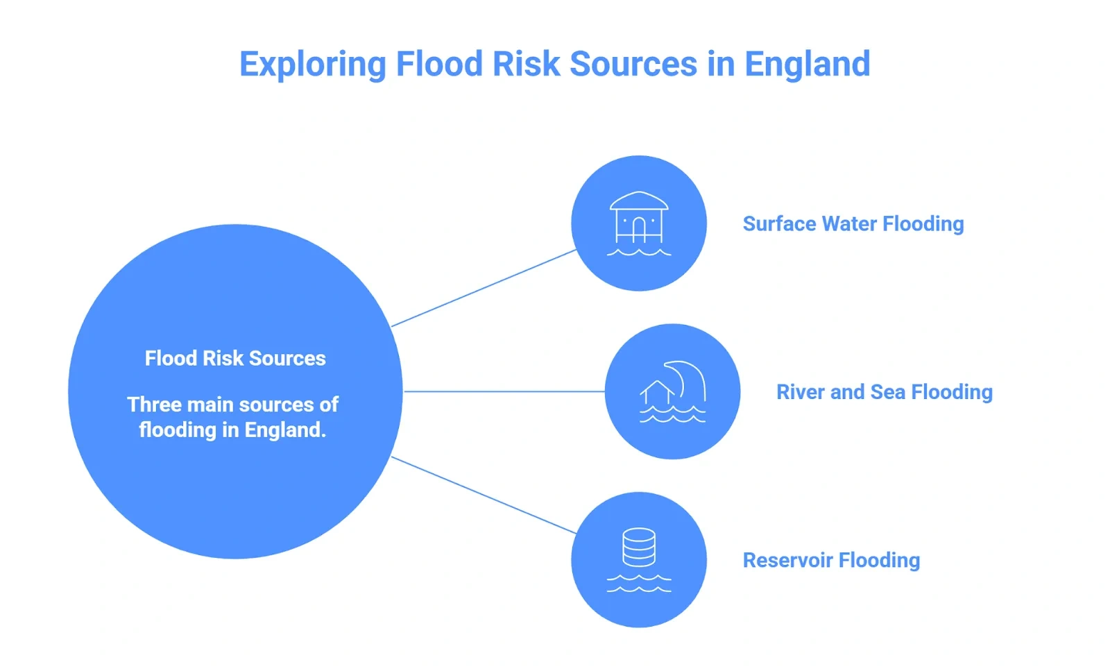
In England, three main sources of flooding are important to consider to check long-term flood risks:
Surface Water Flooding (Pluvial) is caused by heavy rainfall and overwhelms the local drainage system. This type of flooding can run off streets and yards and can occur in properties miles away from the rivers and the sea.
The Environment Agency has released an official national map of Surface Water Flood Risk, which shows that over 4.6 million properties in England are at risk of surface water flooding.
River and Sea (Fluvial/Tidal) is another important source to be checked for long-term flood risks. According to the environmental agency, around 2.6 million properties in England are at risk of Fluvial flooding. And this source of flooding is highly affected by climate change.
Reservoir Flood is rare, but it is caused by a dam or reservoir failure. The Environment Agency provides inundation maps that provide two scenarios:
- “Wet day failure” is a breakage of the reservoir during a river flood.
- “Dry day failure, is a breakage of the reservoir when rivers are low.
When checking the long-term flood risk of your property, do make sure you check if it is closer to a reservoir.
How to Assess Long-Term Flood Risk
The first step in assessing flooding risk is checking the flood zone of your area. If your area is in zone 1, no further assessment is required. But if the area is in zone 2 or 3, you have to perform sequential testing and flood risk assessment.
A sequential test will tell you if an alternative, less risky site is available for development. Flood risk assessment will check for flood risk from all sources and provide mitigation strategies, and prove that development in a zone would not increase the chances of flooding in another era.
RIDA reports provide detailed sequential testing and flood risk assessment services. We aim to not only help with planning permission but also protect a property from flooding and prevent flooding as much as possible.