
Flood Risk Assessment Planning Approval Explained: How Clever Design Unlocked Flood Zone 3
A look at how a car park scheme in a flood-hit site won planning approval, and what it means for flood risk assessments on commercial development.

Flood risk assessment planning approval can be granted even when technical consultees object, as shown by a raised car park scheme approved on a flood hit site despite objections from the Lead Local Flood Authority (LLFA) and council drainage engineers. Planning officers judged that flood resilience and access benefits outweighed the fact the scheme did not meet all national drainage standards, and approval was granted subject to conditions. This case illustrates how the planning balance, flood risk assessment requirements, and drainage standards interact in practice for commercial development in flood zones.
Key takeaways
- A site specific flood risk assessment is required for sites in Flood Zones 2, 3 or 3b, or in Flood Zone 1 at 1 hectare or more.
- Arun District Council approved the Bognor Regis car park scheme despite objections from West Sussex County Council’s lead flood authority and the council’s own drainage engineers, judging that flood resilience and access benefits outweighed the drainage concerns.
- National SuDS standards published in June 2025 set minimum drainage and maintenance requirements, with discharge to combined sewers only as a last resort.
- Approval is often subject to pre commencement conditions, and work cannot lawfully start until these are formally discharged.
- Lost flood storage should normally be replaced through onsite level for level compensatory storage rather than relying on stilts or voids.
What happened at the flood hit Tesco site

Arun District Council has approved a raised car park scheme at a Tesco store on Shripney Road in Bognor Regis, a site with a history of flooding, despite objections from council drainage specialists. The approved design raises some car park spaces by 2m (6ft 6in), allowing customers to park there during periods of flooding.
The new deck proposed deck accommodates 191 spaces, including 22 disabled bays and 18 parent and child spaces. Crucially, the scheme delivers substantial quantitative drainage betterment, slashing the peak surface water discharge into the Aldingbourne Rife from an existing pumped rate of 266 l/s down to a restricted greenfield rate of 9.1 l/s via a new pump and outfall (retaining the 266 l/s infrastructure only for emergency post-flood dewatering). Alongside this, the landscaping proposals deliver 36 broadleaved trees, native shrub planting, species rich grassland, and a new reedbed at the outfall to naturally filter runoff, achieving 0.31 Habitat Units a 91.36% net gain in biodiversity.
Both West Sussex County Council’s lead flood authority and Arun District Council’s drainage engineers objected, citing concerns over flood risk, drainage standards and longterm maintenance. Planning officers concluded the scheme would improve drainage by reducing water discharge into the river, and judged that the flood resilience and access benefits outweighed the fact it did not meet all national drainage standards.
The bottom line: Approval was granted subject to conditions, including detailed drainage plans and measures to offset any loss of floodwater storage, before work can begin. The case shows that mitigation design can satisfy planning officers even where technical consultees object.
Can you get planning permission for a car park in a flood zone?
But this does not remove the need to work through the Sequential Test and, where relevant, the sequential Test.
Usually, planners make developers take a “Sequential Test” to prove they cannot build somewhere with less flood risk. But for Bognor Regis, the council agreed to skip this test. It was obvious that flood defences meant to protect an existing, busy supermarket could not be built anywhere else.
It is also worth clearing up a common rule: car parks are classed as “Less Vulnerable” to flooding, which means they do not have to pass the formal, strict “Exception Test.” Even so, showing a clear benefit to the local community was what won council support. Planning officers decided to bend the usual drainage rules because keeping an essential food store open and dry during heavy storms was far more important for the town. On top of that, the project actually helped the wider neighbourhood by cutting the amount of stormwater pumped into the local river by over 90%.
Development proposals should not present a risk from flooding to potential occupiers, users, or visitors, and should not increase flood risk elsewhere.
In the Bognor Regis determination, Arun District Council clarified how national flood risk tests apply to commercial retail sites. Because commercial car parking and retail uses are classified as “Less Vulnerable” development under the NPPF, the Exception Test was not required at all in Flood Zone 3a. Furthermore, while the Sequential Test normally applies, planning officers determined it could be formally waived; there was no logical alternative site for flood mitigation works specifically designed to make an existing, operational store and its car park resilient to flood events.
Mini Case Study: Securing Approval for 5 New Homes in Flood Zone 3 (Winterbrook, Wallingford)
While commercial car parks are classed as “Less Vulnerable”, new homes are “More Vulnerable” under national policy, facing the toughest scrutiny from the Environment Agency. Yet, RIDA Reports secured planning approval for five new residential dwellings in Flood Zone 3 by designing around three core flood solutions:
- 1,314 m³ of Level-for-Level Storage: 3D terrain modelling proved the site provided over 1,314 m³ of compensatory storage, ensuring floodwaters were never displaced onto neighbours.
- Safe Living Levels: Ground-floor living spaces were set at 46.23 m AOD—providing a safe 300 mm safety buffer above the 1 in 100-year plus climate change flood level (45.93 m AOD).
- Water-Permeable Boundaries: Garden fences and cycle stores were designed with openings up to 530 mm above ground, keeping natural overland flow paths completely open.
The Lesson: Even in high-risk Flood Zone 3, challenging residential sites can secure full Environment Agency backing when mitigation is backed by precision modelling.
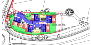
Proposed Site & Flood Compensation Layout (Winterbrook, Wallingford): Showing the 5 raised dwelling footprints (blue), access road, and dedicated lowered terrain (green) providing over 1,300 m³ of level-for-level compensatory flood storage.
What flood risk assessment is needed for commercial development approval
A site specific flood risk assessment (FRA) is required to accompany planning applications for development in areas at risk of flooding. A flood risk assessment is required for development within Flood Zones 2 or 3, within Flood Zone 3b, or within Flood Zone 1 with a site area of 1 hectare or more.
- Model the fluvial flood risk and the design flood for surface water, defined as an event with a 1 in 100 annual probability plus an allowance for climate change
- Assess the upper end climate change allowances for both the 1% and 3.3% annual exceedance probability events for the 2070s epoch
- For major development with surface water drainage, consult the Lead Local Flood Authority
- Where the Environment Agency must be consulted under Schedule 4 of the 2015 Development Management Procedure Order, build in time for that response
Getting planning permission does not guarantee a developer will also get a flood risk permit or consent, which are often needed separately and should be scoped early.
Why raised car park design features as mitigation
Raising some car park spaces by 2m at Bognor Regis, as approved by Arun District Council, allows customers to continue parking there during periods of flooding. Raised finished floor levels should be paired with flood resistant materials and design, with any associated impact on flood risk elsewhere assessed and mitigated.
Where flood storage is lost as a result of development, on site level for level compensatory storage, accounting for climate change impacts over the development’s lifetime, should normally be provided. Stilts and voids below buildings should not normally be relied upon for this, because voids do not allow water to freely flow through them and can become blocked or silted up.
The Tesco scheme resolved this national policy hurdle through three specific engineering measures. First, the deck perimeter is enclosed with screening cladding featuring a minimum 30% open area, allowing floodwaters to flow freely in and out while preventing floating debris from accumulating. Second, the ground beneath the slab was excavated down to 1.17 m AOD (and 1.00 m AOD locally), providing 150 m³ of compensatory storage more than 60 times the 2.4 m³ displaced by the 240 supporting structural posts. Third, this excavation created a minimum 450 mm void height specifically dimensioned to accommodate remote robotic cleaning devices, allowing Tesco to secure an UnderDeck Void Maintenance Plan condition requiring robotic desilting annually and after any flood event.
SuDS for major development need appropriate minimum operational standards and maintenance arrangements to ensure acceptable performance for the development’s lifetime. The national SuDS standards, published in June 2025, also make clear that surface water should be discharged to combined sewers only as a last resort.
Why would planners approve a scheme despite flood risk concerns
The Bognor Regis case shows how planning balance works in practice. A raised car park scheme at a Tesco store on Shripney Road was approved by Arun District Council despite objections from council drainage specialists. Both West Sussex County Council’s lead flood authority and Arun District Council’s drainage engineers objected, citing concerns over flood risk, drainage standards and longterm maintenance.
Planning officers said the scheme would improve drainage by reducing water discharge into the river and judged that flood resilience and access benefits outweighed the fact it did not meet all national drainage standards.
The bottom line: Planning officers approved the car park despite objections from drainage specialists, judging that the flood resilience and access benefits outweighed those concerns, with approval granted subject to conditions including detailed drainage plans and measures to offset any loss of floodwater storage.
This does not mean objections are ignored. All local planning authorities should notify the Environment Agency of the decision on any planning application where the Agency has objected on flood risk grounds, and the Agency publishes an annual list of such cases, indicating whether its advice was followed.
Need a Flood Risk Assessment? RIDA Reports can prepare the flood risk assessment and drainage evidence your planning application needs.
Get in TouchWhat drainage standards apply to car parks in flood prone areas
Car park schemes in flood zones are judged against national SuDS standards. National standards for sustainable drainage systems were published in June 2025, providing a comprehensive seven complementary standards for the design, operation and maintenance of SuDS in new development. They make clear that surface water should be discharged to combined sewers only as a last resort, to help alleviate pressure on sewers and reduce storm sewer overflows.
For greenfield developments, the peak runoff rate to any highway drain, sewer or surface water body for the 1 in 1 year and 1 in 100 year rainfall events should never exceed the peak greenfield runoff rate for the same event. SuDS for major development also need appropriate minimum operational standards and maintenance arrangements, to ensure an acceptable standard of operation for the lifetime of the development.
The Bognor Regis scheme illustrates the attenuation and storage expectations this creates in practice.
Demonstrating ground constraints is essential when standard Sustainable Drainage Systems (SuDS) are not achievable. Ground investigations in February 2025 confirmed that the Bognor Regis car park sub-base is underlain by impermeable cohesive clay down to 2 m depth, with high groundwater hydraulically connected to the river. These conditions completely ruled out infiltration basins, permeable paving, and soakaways under Standard 2 of the National Standards for SuDS. While hydraulic modelling revealed shallow surcharging under the deck during a 1 in 30year storm (<3 mm depth) and 1 in 30 year + 25% climate change event (<7 mm depth), planning officers accepted a formal departure from modern zero ponding standards because the pooling was minor, restricted to non public areas, and offset by massive catchment wide discharge betterment.
Deck capacity191 spaces
The new deck provides an additional 191 parking spaces, including 22 disabled bays and 18 parent and child spaces, raised clear of normal flood levels.
Where flood storage is lost as a result of development, on site level for level compensatory storage, accounting for climate change impacts over the development’s lifetime, should normally be provided. Techniques such as stilts and voids below buildings should not normally be relied upon for this, because voids do not allow water to freely flow through them and can become blocked or silted up.
How are flood risk planning conditions enforced after approval

Approval of the Bognor Regis scheme was granted subject to conditions, including detailed drainage plans and measures to offset any loss of floodwater storage, before work can begin. Development carried out without having complied with a pre commencement condition would be unlawful and may be subject to enforcement action by the local planning authority.
- Pre commencement conditions setThe decision notice lists what must be submitted and approved before any work starts, such as detailed drainage plans and compensatory storage measures.
- Discharge of conditions applicationThe developer submits the flood risk assessment to the local planning authority, which is statutorily required to consult the Environment Agency for developments in certain flood risk areas before granting planning permission.
Carrying out development without required planning permission, or failing to comply with any condition or limitation attached to a planning permission, constitutes unauthorised development that can be subject to local planning authority enforcement action, which may require removal of buildings or works or cessation of an activity.
- Confirm which conditions are precommencement before programming any site works.
- Submit discharge of conditions applications with full technical detail to avoid delay.
- Keep records of EA and LLFA sign off for every discharged condition.
Planning conditions were also used to safeguard underlying water resources. Because the site overlies a sensitive Principal Chalk Aquifer with shallow groundwater, the Environment Agency secured a strict condition prohibiting penetrative foundation piling without a prior Foundation Works Risk Assessment to ensure construction does not create pathways for historic contaminants. Further pre commencement and pre occupation conditions were applied to secure the final structural post schedules, the Under Deck Maintenance Plan, a surface water verification report, and a detailed Car Park Management Plan.
What this means for developers assessing similar sites
The Bognor Regis scheme was approved despite objections from council and lead flood authority drainage specialists over flood risk, drainage standards, and maintenance. Planning officers weighed the flood resilience and access benefits against the fact that the drainage upgrades did not meet all national standards, and approved the application subject to conditions. For developers facing similar sites, the lesson is not that standards are optional, but that evidence and early engagement determine whether an exception can be justified and conditions can be met.
Three practical points follow for any commercial scheme in a flood zone.
- Engage early on the flood risk assessmentWhere surface water or other local flood risks are likely to significantly affect a site, early discussions with the planning authority help identify the issues the FRA must address before an application is submitted.
- Build robust modelling evidenceAssessments should cover the design flood for surface water and the upper end climate change allowances for both the 1% and 3.3% annual exceedance probability events in the 2070s epoch, so objections can be answered with data rather than assertion.
- Plan operational traffic and logistics for flood conditions
Practical resilience extends to access and delivery continuity. In Bognor Regis, the developer designed a dual-mode access strategy: the low lying internal circulation road closes during floods while a dedicated southern ramp opens with active traffic marshaling to guide vehicles straight onto the raised deck. In addition, an unused on site bus stop was converted under a linked planning permission into a flood safe temporary Click & Collect hub to ensure home delivery van operations continue uninterrupted.
The bottom line: A scheme can still fail at the conditions discharge stage even after planning approval, so the technical evidence behind the FRA matters as much as the planning narrative.
Frequently Asked Questions
Can you get planning permission for a car park in a flood zone?
Car parks are generally treated as ‘less vulnerable’ uses under the NPPF flood risk framework, making them easier to justify in higher risk flood zones than uses like housing. However, the Sequential Test still applies, and the Exception Test may also apply, meaning developers must show wider sustainability benefits and that the site will be safe for its lifetime without increasing flood risk elsewhere.
What flood risk assessment is needed for commercial development approval?
A site specific flood risk assessment is required for development in Flood Zones 2 or 3, Flood Zone 3b, or Flood Zone 1 sites of 1 hectare or more. It must model fluvial flood risk and the design flood for surface water, including upper end climate change allowances for the 1% and 3.3% annual exceedance probability events for the 2070s epoch, and major development must consult the Lead Local Flood Authority.
Why would planners approve a scheme despite flood risk concerns?
Planning officers can grant permission against the objections of technical consultees such as the Environment Agency or Lead Local Flood Authority if they judge the wider benefits of a scheme sufficient under the NPPF paragraph 11 presumption in favour of sustainable development. In the Bognor Regis case, officers judged that flood resilience and access benefits outweighed the fact the scheme did not meet all national drainage standards, provided conditions addressed the specific concerns raised.
What drainage standards apply to car parks in flood prone areas?
Car park schemes are judged against the national SuDS standards published in June 2025, which set a seven point framework for design, operation and maintenance, and state that surface water should only be discharged to combined sewers as a last resort. For greenfield sites, peak runoff rates for the 1 in 1 year and 1 in 100 year events should never exceed the peak greenfield runoff rate for the same event, and any lost flood storage should normally be replaced on a level for level basis.
How are flood risk planning conditions enforced after approval?
Conditions such as detailed drainage plans and compensatory storage measures are typically pre commencement, meaning a developer cannot lawfully start construction until the local planning authority has formally discharged them. Enforcement sits with the local planning authority under the Town and Country Planning Act, and starting work before conditions are discharged can lead to enforcement action, including requirements to undo unauthorised works.
Sources
- Flood-hit Tesco in Bognor wins approval for raised car park
- Flood and coastal erosion risk management annual report
- Use of planning conditions
- Flood risk assessment: Flood Zones 1, 2, 3 and 3b
- Flood risk and coastal change
- Flood risk assessments: climate change allowances
- National flood risk standing advice for local planning authorities
- Enforcement and post-permission matters
Recommended sources
Planning a Development in a Flood Zone?
Talk to RIDA Reports about a flood risk assessment that gives planners and drainage consultees the evidence they need.
Contact RIDA Reports