
Understanding EA flood zones is important for anyone planning to develop a property in England. The Environmental Agency defines these flood zones based on the likelihood of flooding from different sources, such as rivers. Learning about a site’s EA flood zone is the first step in obtaining planning permission and deciding on flood risk assessment.
This guide will explain:
- What are EA flood zones?
- How to use the official Flood Map for Planning.
- Why these zones matter for development.
Environmental Agency’s Role in Defining Flood Risk
The Environmental Agency is a national organisation working to improve and protect the environment throughout England. In addition to managing flood risks, it also monitors climate change, protects wildlife, and oversees waste management.
Under the Flood and Water Management Act (2010), it works alongside side UK government and other agencies to deliver the national flood strategy, allocate flood funds, and provide flood risk data and advice.
The EA compiles flood zones across England as part of the national flood map for planning. The flood zones are updated regularly, and this year they were updated in the quarter of 2025. Local authorities consult the EA’s database when planning and reviewing applications that come under certain flood zones. The flood zone map is available on their website for public use
What are EA Flood Zones?
EA flood zones classify land by flood probability from rivers and the sea. The EA publishes these flood zones map online, and you can search by postcode, place name, or coordinates (easting/northing or grid reference). They do not account for flood protection defences when classifying land and focus only on major flood sources, unlike small streams, drainage ditches and etc. The earlier versions of the map also did not include future climate change impacts.
They use local models and past flood records to classify land into three categories:
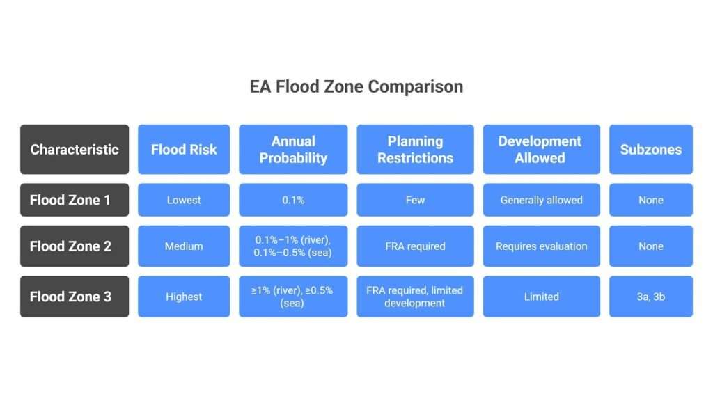
Flood Zone 1 – The Lowest Risk
Flood zone 1 has <0.1% (1/1000) annual flood chance. This zone covers all land not placed in zones 2 and 3. Hence, it contains the largest area of England.
- It has a few planning restrictions; generally, you can build anything here
- If the selected development area is bigger than 1 hectare (1 ha), flood risk assessment must be carried out in zone 1.
- A surface water issue, like critical drainage, can also trigger an FRA.
Please note that this zone is not completely free from flood risks; a flood can be triggered from sources not noted by EA flood maps, like water drainage. It is best to plan for flood risk assessment in zone 1 to be fully sure about your site
Flood Zone 2 – Medium Risk
Flood zone 2 has a probability of 0.1%–1% annual chance of river flooding, or 0.1%–0.5% chance of sea/coastal flooding. It basically covers all land where flooding is possible but not frequent.
- Any development proposal in flood zone 2 requires an FRA. All proposals based in zone 2, even the smaller ones, require evaluation by flood specialists.
- The light blue area on the planning map is flood zone 2. It includes areas such as minor river floodplains or coastal areas that flood occasionally.
Flood Zone 3 – Highest Risk
Flood zone 3 has ≥1% annual probability of river flooding, or a ≥0.5% annual probability of sea flooding. This zone has the highest risk of flooding, and typically corresponds to areas closer to the sea.
- Any development in this zone requires a flood risk assessment.
- House development is usually not allowed in this zone
- This zone is shown as zone 3 on the flood map, but it is divided into 3a zone and 3b zone.
- The zone 3a is a zone where water typically reaches in times of flooding. The subcategories of zone 3 are not specified on the map, but you can identify them using local Strategic Flood Risk Assessment (SFRA) or detailed studies.
- The zone 3b, also called the Functional Floodplain, is the zone that floods first and the hardest. This zone has 1 in 30 (3.3%) chances of flooding every year. Almost all new developments are prohibited in this zone.
Get A Free No Obligation Quote
Accessing the Flood Map for Planning Service

The UK government provides the flood map for the planning service. This map is available on gov.uk’s website and is frequently updated. Key features of this service include:
- FRA requirement: The flood risk map shows all three flood zones. And if your area is based in flood zone 2 or 3, this means you require a flood risk assessment. This tool specifically tells you whether you need an FRA or not.
- Downloadable map: You can download and print this map from gov.uk ‘s website. The map shows flood zones, main rivers, the sea, and other features.
- Raw data: Consultants, developers, or even architects can request underlying flood risk data for detailed analysis.
- Other data layers: The flood map for planning also shows flood defences, main river designations, water storage areas, etc. You can even check climate change extents through the updated version of this service.
Flood Risk Assessments (FRA) and Regulatory Compliance
After identifying whether you come under flood zone 1, 2, or 3, your next step is to plan for Flood risk assessment. If your area comes under flood zone 2, 3, or is more than 1 ha in zone 1, you need a flood risk assessment.
A professional,policy-compliant flood risk assessment:
- Identifies flood sources.
- Shows the extent of flooding.
- Explains possible flood impact.
- Recommends ways to reduce risk.
- Helps with planning permission.
Contact us today for a flood risk assessment that meets local and national policies, helps you with planning permission, and provides you with safety from lifetime flood risks.
EA Standing Advice for Certain Developments
Standing advice is pre-written rules for specific development by the environmental agency, which lets you skip a full technical FRA for small-scale, low-risk developments. Standing advice applies to minor extensions (under 250 m² in Zones 2 or 3). If your application falls under this category, you can follow EA’s advice instead of submitting a full FRA report.
The process to gain EA’s standing advice is simple ;
- Access the flood risk map for planning
- Identify the flood zones
- Check if your development falls under a minor extension or a low-risk case
- In your planning application, mention that your site and development fall under EA Standing Advice. Attach EA’s pre-written templates.
- Your application will be accepted without an FRA requirement if you meet the qualification criteria.
Limitations of EA Flood Zone Data
Although the EA flood zone map for planning is an indispensable tool, it still has some limitations. Let’s go through them one by one together:
- Static present-day view: The basic flood zone map only shows current risks, ignoring climate change. But fortunately, in 2025, the EA introduced a new layer into flood zones,” Flood Zones plus Climate Change”. This layer predicts how Zones 2/3 are expected to expand under future seniors.
- Ignores flood defences: The zone data completely ignores flood defences. Your property might be flood-protected, but the map will still treat your property as at risk if it is in zone 2 or 3.
- Excludes small water features: The flood risk data in this map is only based on the sea and rivers. Other sources, like groundwater, canals, or drainage, are not included. So there is a possibility, your property can flood even in zone 1, because of, say, local drainage failure.
- Data reliability: The EA itself states the data is “without any guarantees.” The map is based on data that can change and uncertain models. For better protection, opt for a flood risk assessment and protect yourself from all the hassle.
Get A Free No Obligation Quote
How Rida Reports Overcome the Limitations of the EA Flood Map
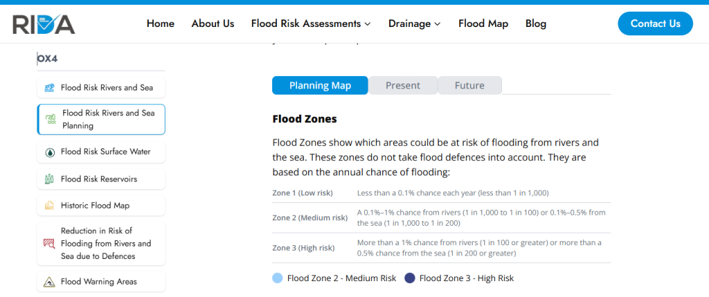
The EA flood map serves as an indicator, but it does not give you all the information you need for planning protection and flood risk management. Rida reports not only acts as a translator of EA flood maps, but also provides information that is not available on the flood map. For example, you can find flood zone 3b on our website in the flood risks Rivers and Sea Planning /Future tab.
Our services ensure all risks are assessed(fluvial, tidal, pluvial, and groundwater) and provide the detailed velocity, volume, and depth data critical for critical projects. You can view current and present extents of a flood zone, along with the corresponding depths.
The table below summarises how Rida Reports bridges the information gap between the EA data and the requirements of the planning system.
| Precisely mapped Flood Zone 3b, essential for Sequential/Exception Tests and maximising developable land. | Basic EA Flood Map for Planning (Public Data) | Rida Reports Detailed Flood Risk Assessment (Bespoke) |
| Mapping Resolution | General zone boundaries based on national models. | Site-specific boundary verification using detailed hydraulic models based on local topography. |
| Climate Change Risk | Static present-day view; optional ‘Future Extent’ layer (no depth). | Detailed modeling of future extents and associated flood depths (m) using mandated climate allowances. |
| Flood Depth & Velocity | Not included, insufficient for engineering design. | Quantified flood depth (m) and velocity (m/s) are crucial for setting Finished Floor Levels and structural design. |
| Functional Floodplain (FZ 3b) | Not explicitly shown; reliant on external SFRA or self-assessment. | Precisely mapped Flood Zone 3b, essential for Sequential/Exception Tests and maximizing developable land. |