

Call Us

01608 510 121

Email Us

admin@rida-reports.co.uk

Flood Check: How to Check for Flooding in England

How to Check for Flooding in England

England has one of the most efficient flood monitoring systems. Different official sources provide information about flooding and flood risk, and much of it can be explored together using a flood risk map.

Today, in this blog, we are going to cover all flood checking tools you can use to check for flood:

  • Flood check by postcode 
  • Flood check by different sources
  • Long-term flood check
  • Flood zone information 
  • Current flood updates


In addition to enlisting all tools, this guide will also describe how to access and read them.

You can check all of these sources of flooding on our website. Just enter your postcode and look at your flood risk.

Real-Time Flood Check 

Real-time flood check is extremely important to stay safe and take action in time. The Environment Agency understands this and has “ Check for Flooding” available on its website.

This tool shows you real-time flood alerts and warnings by location or postcode. For example , on 8 January 2026, this tool showed 8 flood warnings and 103 flood alerts.

You can also access this service through their Floodline (0345 988 1188, 24/7). A responder will brief you about all current flood alerts and warnings. It will also verbally update you about no flood warnings or alerts for the day. 

Besides alerts, an online service for live sensor data is available as well. The Enviroment Agency’s online service links to the Find river, sea, groundwater and rainfall levels page. You simply have to add a river name or location to view the latest water level readings. 

Flood Check by Postcode – Planning Only

The Environment Agency has divided the land of England into three flood categories and provides an online  “ flood map for planning” service:

  • Flood Zone 1: lowest risk 
  • Flood Zone 2: medium risk 
  • Flood Zone 3: highest risk (Flood Zone 3 is divided into Flood Zone 3a and Flood Zone 3b)


These flood zones play a key role in planning, including application, permission and development. This tool is available on the gov.uk website and requires an address or postcode to show the following information:

  • Is your site in Flood zone 1, 2 or 3 
  • Is there any surface water flood risk
  • Future flood probability due to climate change 
  • Rivers near your area
  • Presence of flood defences


Please note that this service provides area-wise information. If you want information specifically about your property, you can contact us at RIDA Reports for a free quote and book a flood risk assessment. 

Long-Term Flood Risk Check

The government of the UK also provides “Check Long-Term Flood Risk” for a detailed view of current and future flood potential and probability. And generally, long-term flood risk information is extremely important in countries like England with a lot of floodplains.

You can enter a postcode or an address and get a flood probability summary, which covers rivers, the sea, surface water, groundwater and reservoirs. It also provides information in terms of climate change, like how climate change is likely to increase an area’s flood risk.

If we compare this with the simple flood zone map, the long-term flood check is dynamic and covers multiple hazards. Also, it gathers data from EA’s national flood risk assessment, flood map for planning, flood models and climate scenarios to give overall efficient flood risk information. It is most likely to catch every risk that flood maps can miss.

Long-term flood check is important for future-oriented decisions, especially when developing, buying or selling land. For instance, if you do not check long-term flood risk and end up constructing a house in a high flood risk zone, you will face not only flood risk but also financial problems like expensive insurance. 

Flood Check by Source
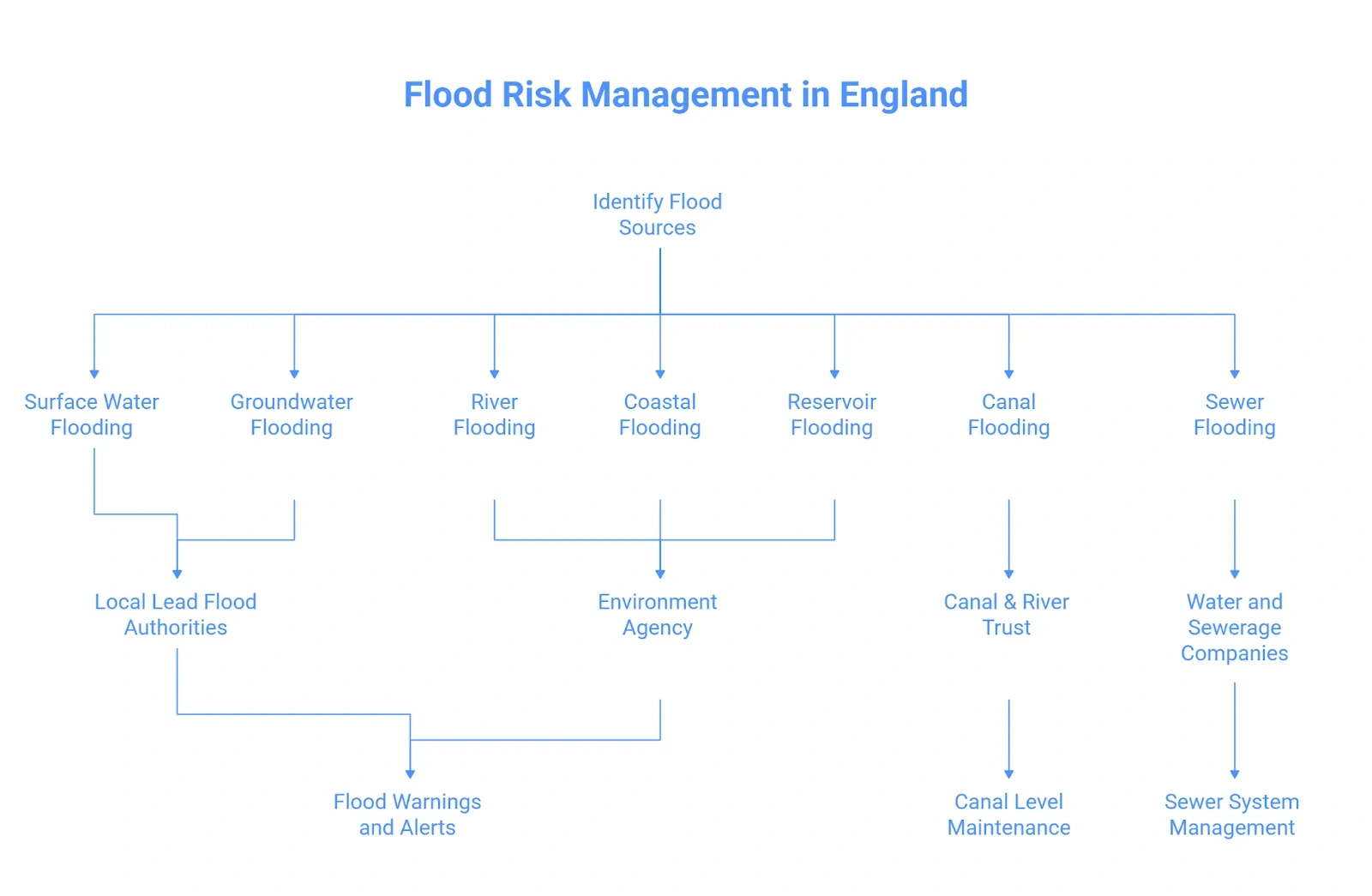
Flood Risk Management in England


England has a lot of flood sources:

  • Flood risk from rivers
  • Flood risk from the sea, like a storm
  • Flood risk of surface water due to heavy rainfall
  • Flood risk from groundwater when the water table rises above the ground surface
  • Flood risk from reservoirs, if they run out of water storage capacity.


So it is extremely important to check for flood risk from all sources individually. 

River flooding

River channels can be overwhelmed by heavy rainfall, which can cause bank bursting, resulting in a flood. The Enviroment Agency manages the main rivers and large channels. The EA regularly issue flood warnings and flood alerts based on river water levels. The EA also manages flood defences on major rivers and monitors water levels 24/7.

Lastly, all the tools we have covered so far, such as the flood map for planning, account for river flood risk.

Surface water flooding 

Surface water flooding is also known as pluvial flooding. It happens due to heavy rainfall overwhelming drainage systems, and water runs over land. Currently, over 4.6 million properties in England are at risk of pluvial flooding, making it a widespread risk.

The Local Lead Flood Authorities usually oversee and manage pluvial flood risk. The Enviroment Agency plays more of a strategic role in pluvial flood risk and provides national guidance and surface water flood maps. 

The local councils handle drainage issues, deploy drainage systems and plan for flash floods.

Groundwater flooding

Groundwater flooding occurs after many days of prolonged rain, and it is characterised by a rise of the water table above the ground surface. This flooding is most likely to affect basements and saturated fields. 

The Lead Local Flood Authority also manages this source of flooding, including day-to-day management. The Environment Agency plays a strategic role and oversees other authorities handling groundwater flooding. The EA also publishes regional groundwater situation reports. To inform planners. 

Coastal flooding

Storm surges and high tides can cause seawater to enter land and cause flooding. The Environment Agency manages everything related to coastal flooding, including flood warning, flood defences and gathering coastal data. 

Residents near the coast can watch both the EA flood warning and the MET Office’s 5-day weather reports to stay safe and prepared. 

Canal flooding

Canals, the navigable waterways, are not a major source of flood, but they can overflow when the water level rises due to operational failure, breach or vandalism. There is no official canal flood alert service, but canal owners, such as  Canal & River Trust or private companies, are involved in canal management. 

In simple words,  Canal & River Trust maintains canal levels, and any issue will be maintained by them and not the Environment Agency or any other authority. 

Sewer flooding

Sewer flooding is caused by overflow or blockage of sewer systems. Sewer flooding is specific to individual streets or basements, and it is handled by local water and sewerage companies, like Thames Water.

The EA and local authorities guide these private companies and expect them to handle all issues related to sewage systems.

Reservoir flooding

An unfortunate and unlikely event of a dam or reservoir failure can result in a flood quickly. Fortunately, the large reservoirs in England are regulated under the Reservoir Act with regular inspection and emergency plans. 

The Enviroment Agency has also published the Reservoir Flood Map that shows “dry-dry” and “wet-dry” failure scenarios. You can access these maps via the long-term flood service. Reservoir flooding is a risk, but it is very rare because of specialised planning, regular inspections and emergency preparedness. 

What is Next After the Flood Check? 
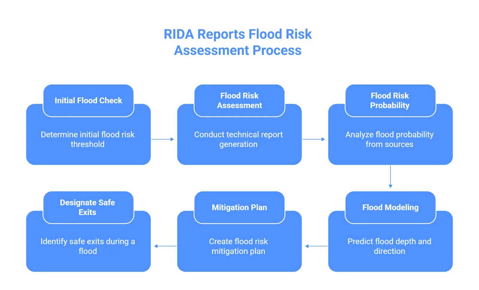
Flood check is an initial step of flood planning; it is a threshold to determine which direction you are supposed to take. Also, an individual flood check will only show you your area’s flood risk, but you would not be able to tell the probability and depth of flood without professional help. 

Flood Risk Assessment is a technical report which includes:

  • Flood risk and probability from all sources 
  • Performing flood models to analyse and predict flood depth and direction
  • Create a flood risk mitigation plan in terms of planning.
  • Designate safe exits during a flood.


We at RIDA reports are experts in our field, our engineers perform flood risk assessment with advanced tools, 20+ years of experience and following national policies such as the NAFRA2. Contact us today for a free quote. 

Frequently Asked Questions

You can use the Check for Flooding tool by the Enviroment Agency to check for the current flood risk. After you add your address or postcode, you will get information about any flood warnings, flood alerts and 5 5-day weather reports.

EA Flood Zones is a static map that categorises the land of England into flood zones based on risk, and it does not update every day or provide future scenarios. On the other hand, the long-term flood risk check is dynamic and accounts for climate change and future scenarios. 


If the flood is about to happen (flood alerts/warning), act immediately: have your flood kit and flood plan ready. move all important stuff upstairs, turn off gas and electricity connections and put sandbags if available at doors. 

Conclusion 

England’s flood risk has been managed well by the official and local authorities. You can check flood risk by different tools, by different sources and for different purposes. These flood checks help in planning, development, flood prevention and management.

The next step after flood check is flood risk assessment. Flood risk assessment is extremely important for planning permission, property-specific assessment and planning mitigation strategies. 

Table of Contents